ベム (インドネシア)
ベム Bemu | |
|---|---|
|
町 | |
| 座標:南緯3度24分15秒 東経129度58分29秒 / 南緯3.40417度 東経129.97472度座標: 南緯3度24分15秒 東経129度58分29秒 / 南緯3.40417度 東経129.97472度 | |
| 国 | インドネシア |
| 州 | マルク州 |
| 等時帯 | UTC+8 (WITA) |
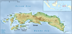
ベム (Bemu) あるいはベモ・ペラク (Bemo Perak) は、インドネシア・セラム島の南東部沿岸にある町。アティアフのすぐ南に位置する[1]。テルティ湾周辺における主要な集落の一つである[2]。
参考文献[編集]
- ^ “Seram Island (map)”. Indonesiatravelingguide.com. 2015年6月8日閲覧。
- ^ Prostar Sailing Directions 2004 New Guinea Enroute. ProStar Publications. (1 January 2004). p. 56. ISBN 978-1-57785-569-9

