カンタベリー湾
| カンタベリー湾 Canterbury Bight | |
|---|---|
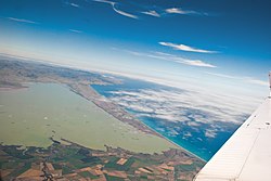
 カンタベリー湾の北端、カイトレト・スピット(Kaitorete Spit)とエルズメア湖(Lake Ellesmere/Te Waihora)の航空写真 | |
|
カンタベリー湾は、バンクス半島から南側のカンタベリー海岸の大部分を占める | |
| 位置 | カンタベリー地方, ニュージーランド |
| 座標 | 南緯44度15分 東経171度38分 / 南緯44.250度 東経171.633度座標: 南緯44度15分 東経171度38分 / 南緯44.250度 東経171.633度 |
| 種類 | 海の湾 |
| 主な流入 | en:Lake Ellesmere / Te Waihora, en:Rakaia River, en:Ashburton River / Hakatere, en:Rangitata River |
| 主な流出 | 太平洋 |
| 国 | ニュージーランド |
| 主な沿岸自治体 | ティマルー |
カンタベリー湾(Canterbury Bight)は、ニュージーランド南島の東海岸にあるバンクス半島の南に位置する湾である。ラカイア川(w:Rakaia River)やランギタタ川(w:Rangitata River)などの河口がある。湾の外には太平洋が広がっている。


