
ファイル:View of the Margaret Hunt Hill Bridge, a Santiago Calatrava-designed bridge over the Trinity River in Dallas, Texas LCCN2014632135.tif

この TIF ファイルのこの JPG プレビューのサイズ: 800 × 449 ピクセル. その他の解像度: 320 × 180 ピクセル | 640 × 359 ピクセル | 1,024 × 575 ピクセル | 1,280 × 719 ピクセル | 2,560 × 1,438 ピクセル | 6,559 × 3,684 ピクセル。
元のファイル (6,559 × 3,684 ピクセル、ファイルサイズ: 164.55メガバイト、MIME タイプ: image/tiff)
ウィキメディア・コモンズのファイルページにある説明を、以下に表示します。
|
概要
| 解説 |
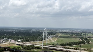
English: Title: View of the Margaret Hunt Hill Bridge, a Santiago Calatrava-designed bridge over the Trinity River in Dallas, Texas
Physical description: 1 photograph : digital, tiff file, color. Notes: The bridge is named for Margaret Hunt Hill, a Dallas entrepreneur and philanthropist, who was the daughter of legendary oilman H.L. Hunt.Construction on the bridge began in spring 2007 with the steel manufactured in an Italian steel factory often used by Calatrava to realize his designs. It connects Texas Spur 366 (the Woodall Rodgers Freeway) downtown to Singleton Boulevard in west Dallas.; Title, date, and keywords based on information provided by the photographer.; Gift; The Lyda Hill Foundation; 2014; (DLC/PP-2014:054).; Forms part of: Lyda Hill Texas Collection of Photographs in Carol M. Highsmith's America Project in the Carol M. Highsmith Archive.; Credit line: The Lyda Hill Texas Collection of Photographs in Carol M. Highsmith's America Project, Library of Congress, Prints and Photographs Division. |
||||||||||||||||||||||||||
| 日付 | 撮影日:2014年5月11日, 14:26(Exifデータによる) | ||||||||||||||||||||||||||
| 原典 |
Library of Congress
|
||||||||||||||||||||||||||
| 作者 |
|
||||||||||||||||||||||||||
| 許可 (ファイルの再利用) |
No known restrictions on publication.
|
||||||||||||||||||||||||||


| カメラの位置 | | 以下のサービスでこの位置を確認する: オープンストリートマップ |
|---|
ライセンス
| この著作物はアメリカ議会図書館Carol M. Highsmith Archiveのコレクション収蔵品です。同図書館によれば、この著作物の使用に関しては著作権に依拠する如何なる制限事項も認められません。 Carol M. Highsmith has stipulated that her photographs are in the public domain. Photographs of sculpture or other works of art may be restricted by the copyright of the artist. |
 |
ファイルの履歴
過去の版のファイルを表示するには、その版の日時をクリックしてください。
| 日付と時刻 | サムネイル | 寸法 | 利用者 | コメント | |
|---|---|---|---|---|---|
| 現在の版 | 2016年9月27日 (火) 06:47 |  | 6,559 × 3,684 (164.55メガバイト) | Fæ | LOC 2014632135, Carol M. Highsmith collection. P727.21849 TIFF (164.5mb) |
ファイルの使用状況
以下のページがこのファイルを使用しています: