
ファイル:Bevölkerungsprognosen Baruth.pdf

この PDF ファイルのこの JPG プレビューのサイズ: 800 × 566 ピクセル. その他の解像度: 320 × 226 ピクセル | 640 × 453 ピクセル | 1,024 × 724 ピクセル | 1,280 × 905 ピクセル | 1,752 × 1,239 ピクセル。
元のファイル (1,752 × 1,239 ピクセル、ファイルサイズ: 68キロバイト、MIME タイプ: application/pdf)
ウィキメディア・コモンズのファイルページにある説明を、以下に表示します。
|
概要
| 解説 |
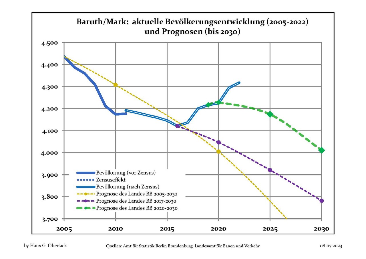
Deutsch: Aktuelle Bevölkerungsentwicklung (blaue Linien) und Prognosen (punktierte Linien) für Baruth/Mark , Landkreis Teltow-Fläming, Land Brandenburg, Deutschland
English: Recent population development (blue lines) and projections (dotted lines) of Baruth/Mark, Teltow-Fläming district, Brandenburg state, Germany
Español: Tendencias actuales (lineas azules) y previsiones (lineas de puntos) de la poblacion de Baruth/Mark, distrito de Teltow-Fläming, estado de Brandenburg, Alemania
Français : Évolution actuelle de la population (lignes bleues) et projections démographiques (lignes pointillées) de Baruth/Mark, arrondissement de Teltow-Fläming, Land de Brandebourg, Allemagne
Italiano: Sviluppo recente della popolazione (linea blu) e previsioni demografiche (linee puntinate) di Baruth/Mark, circondario di Teltow-Fläming, stato federato del Brandeburgo, Germania
Nederlands: Recente ontwikkeling van de bevolking (blauwe lijn) en prognoses (stippelijn) van Baruth/Mark, landkreis Teltow-Fläming, deelstaat Brandenburg, Duitsland
Polski: Obecne tendencje (niebieska linia) i prognozy demograficzne (linia przerywana) dla Baruth/Mark, powiat Teltow-Fläming, kraj Brandenburgia, Niemcy
Svenska: Aktuella befolkningsutveckling (blå linjen) och prognoser (prickade linjen) av Baruth/Mark, landkreis Teltow-Fläming, delstaten Brandenburg, Tyskland |
| 日付 | 2012年10月12日と2023年7月8日の間 |
| 原典 | 次の画像を基にした投稿者自身による著作物: Data sources displayed at Population Projection Brandenburg at Wikimedia Commons |
| 作者 | Hans G. Oberlack |
| Latest population data | 2022 |
| Latest population forecast | LBV 2020-2030 |
| Type of municipality | amtsfrei |
| 被写体の位置 | | 以下のサービスでこの位置を確認する: オープンストリートマップ |
|---|
ライセンス
この作品の著作権者である私は、この作品を以下のライセンスで提供します。
このファイルはクリエイティブ・コモンズ 表示-継承 3.0 非移植ライセンスのもとに利用を許諾されています。
- あなたは以下の条件に従う場合に限り、自由に
- 共有 – 本作品を複製、頒布、展示、実演できます。
- 再構成 – 二次的著作物を作成できます。
- あなたの従うべき条件は以下の通りです。
- 表示 – あなたは適切なクレジットを表示し、ライセンスへのリンクを提供し、変更があったらその旨を示さなければなりません。これらは合理的であればどのような方法で行っても構いませんが、許諾者があなたやあなたの利用行為を支持していると示唆するような方法は除きます。
- 継承 – もしあなたがこの作品をリミックスしたり、改変したり、加工した場合には、あなたはあなたの貢献部分を元の作品とこれと同一または互換性があるライセンスの下に頒布しなければなりません。
ファイルの履歴
過去の版のファイルを表示するには、その版の日時をクリックしてください。
| 日付と時刻 | サムネイル | 寸法 | 利用者 | コメント | |
|---|---|---|---|---|---|
| 現在の版 | 2023年7月8日 (土) 09:42 |  | 1,752 × 1,239 (68キロバイト) | Hans G. Oberlack | 2022 data added |
| 2022年9月17日 (土) 08:21 |  | 1,752 × 1,239 (125キロバイト) | Hans G. Oberlack | 2021 data added | |
| 2021年9月30日 (木) 19:26 |  | 1,752 × 1,239 (124キロバイト) | Hans G. Oberlack | New official forecast and 2020 data added | |
| 2020年7月19日 (日) 10:49 | サムネイルなし | 0 × 0 (125キロバイト) | Hans G. Oberlack | 2019 data added | |
| 2019年10月31日 (木) 22:51 | サムネイルなし | 0 × 0 (137キロバイト) | Hans G. Oberlack | 2018 data added | |
| 2019年3月10日 (日) 11:21 | サムネイルなし | 0 × 0 (124キロバイト) | Hans G. Oberlack | Latest official forecast added | |
| 2018年9月30日 (日) 06:40 | サムネイルなし | 0 × 0 (119キロバイト) | Hans G. Oberlack | 2017 data added | |
| 2018年1月20日 (土) 13:24 | サムネイルなし | 0 × 0 (118キロバイト) | Hans G. Oberlack | New official forecast and data for 2014, 2015 and 2016 added | |
| 2014年11月2日 (日) 20:19 | サムネイルなし | 0 × 0 (96キロバイト) | Hans G. Oberlack | 2013 data added | |
| 2013年9月6日 (金) 19:47 | サムネイルなし | 0 × 0 (96キロバイト) | Hans G. Oberlack | Census and 2012 data added |
ファイルの使用状況
以下のページがこのファイルを使用しています:
グローバルなファイル使用状況
以下に挙げる他のウィキがこの画像を使っています:
- en.wikipedia.org での使用状況
- es.wikipedia.org での使用状況
- it.wikipedia.org での使用状況
- uk.wikipedia.org での使用状況