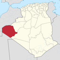
ティンドゥフ県
ティンドゥフ県 ولاية تندوف | |
|---|---|
|
県 | |
 | |
| 座標:北緯27度41分 西経8度8分 / 北緯27.683度 西経8.133度座標: 北緯27度41分 西経8度8分 / 北緯27.683度 西経8.133度 | |
| 国 |
|
| 県都 | ティンドゥフ |
| 面積 | |
| • 合計 | 159,000 km2 |
| 人口 | |
| • 合計 | 160,000人 |
| • 密度 | 1.0人/km2 |
| 等時帯 | UTC+01 (CET) |
| 市外局番 | +213 (0) 49 |
| ISO 3166コード | DZ-37 |
| 地区 | 1 |
| 基礎自治体 | 2 |
ティンドゥフ県(Tindouf)は、アルジェリア民主人民共和国の西部に位置する県。県都はティンドゥフ。人口は27060人(1998年、西サハラ難民含む)。モロッコと西サハラ、モーリタニアに接し、マリにも近い。
歴史[編集]
en:Tajakantの町だったが、1895年に遊牧民en:Reguibat tribeに占領された。 アルジェリアの独立前、遊牧民の部族連合の拠点だった。
1963年、en:Sand War。 en:Western Sahara War(1975年-1991年)中には、en:First Battle of Amgala (1976)の基地となった。 県内に西サハラから脱出してきたサハラウィー人難民のキャンプが存在する(en:Sahrawi refugee camps)。
地理[編集]
地理的に不毛だが、豊富な資源を有し、マリとの国境付近に多量の鉄鉱石が存在する。
戦略的重要性[編集]
3カ国が接するティンドゥフ県には、アルジェリアの陸軍および空軍基地が存在する。
脚注[編集]
- ^ Office National des Statistiques, Recensement General de la Population et de l’Habitat 2008 Archived 2008-07-24 at the Wayback Machine. Preliminary results of the 2008 population census. Accessed on 2008-07-02.
- 注釈
- ^ Sahrawis are not legally recognized as dwellers of the province but rather as illegal or temporary refugees and migrants in Sahrawi refugee camps. Their exact number is unknown.
