
ファイル:Soviet caucasus1922.png

このプレビューのサイズ: 800 × 571 ピクセル。 その他の解像度: 320 × 229 ピクセル | 640 × 457 ピクセル | 1,024 × 731 ピクセル | 1,280 × 914 ピクセル | 1,613 × 1,152 ピクセル。
元のファイル (1,613 × 1,152 ピクセル、ファイルサイズ: 127キロバイト、MIME タイプ: image/png)
ウィキメディア・コモンズのファイルページにある説明を、以下に表示します。
|
概要
| 解説 |
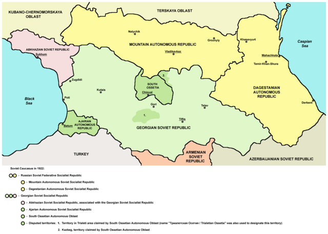
English: Northern part of Soviet Caucasus in 1922 - Mountain Autonomous Soviet Socialist Republic, Dagestanian Autonomous Soviet Socialist Republic, Georgian Soviet Socialist Republic, Abkhazian Soviet Socialist Republic, Ajarian Autonomous Soviet Socialist Republic, South Ossetian Autonomous Oblast and disputed territories claimed by South Ossetian Autonomous Oblast (Trialeti area / Trialetian Ossetia and Kazbeg). |
| 日付 | |
| 原典 | 投稿者自身による著作物 |
| 作者 | PANONIAN |
| その他のバージョン |
|

ライセンス
| この著作物の著作権者である私は、この著作物における権利を放棄しパブリックドメインとします。これは全世界で適用されます。 一部の国では、これが法的に可能ではない場合があります。その場合は、次のように宣言します。 私は、あらゆる人に対して、法により必要とされている条件を除き、如何なる条件も課すことなく、あらゆる目的のためにこの著作物を使用する権利を与えます。 |
References
Made according to these sources:
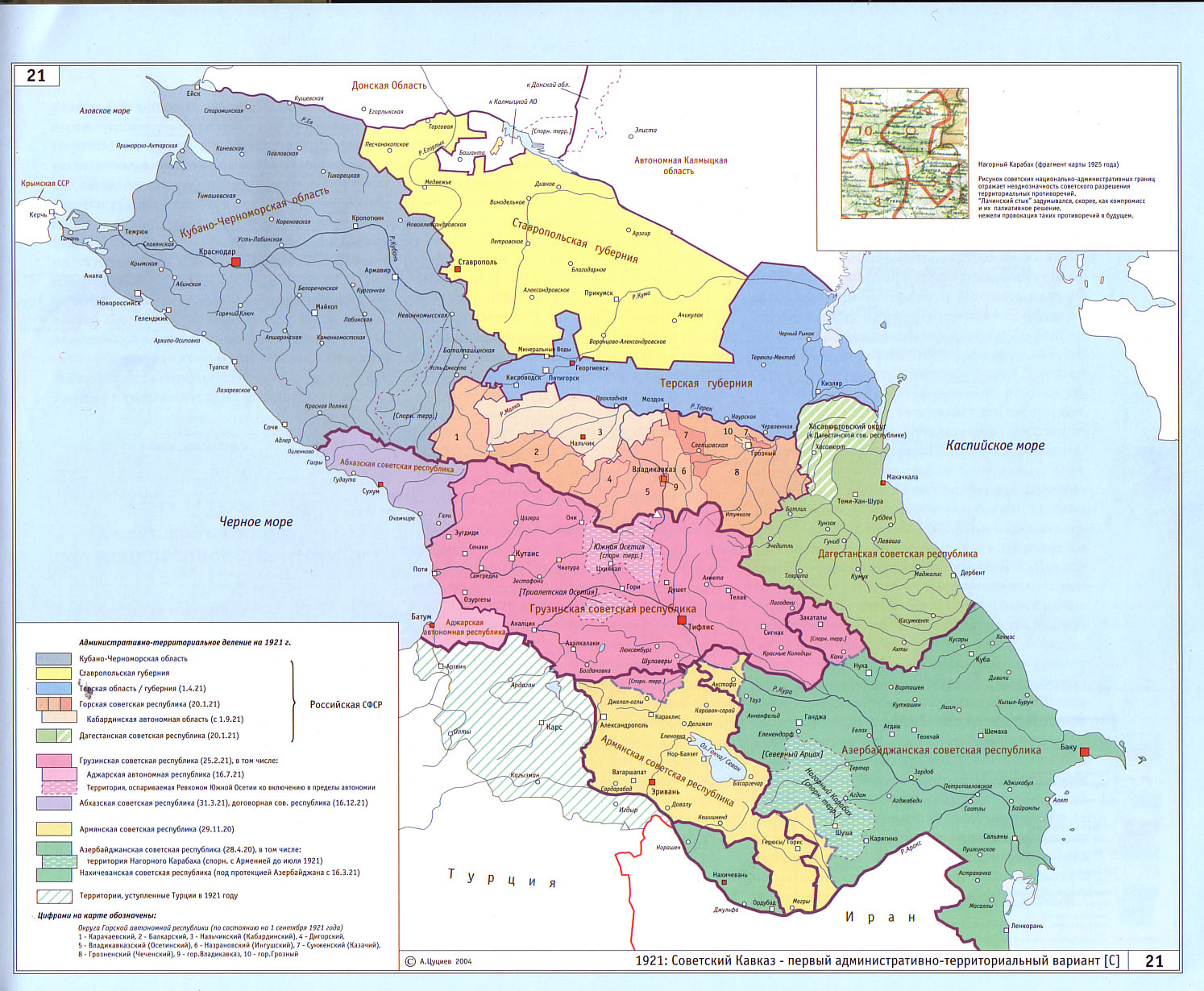
- http://www.iriston.com/books/cuciev_-_etno_atlas/cuciev_etno-polit_map.htm - 50 maps from book "АТЛАС ЭТНОПОЛИТИЧЕСКОЙ ИСТОРИИ КАВКАЗА", Цуциев А.А, Москва: Издательство «Европа», 2007. ("Atlas of ethnopolitical history of Caucasus", Tsutsiev A.A, Moscow: Publisher «Evropa», 2007), inluding a map of Soviet Caucasus in 1921, which show Mountain Autonomous Soviet Socialist Republic, Dagestanian Autonomous Soviet Socialist Republic, Georgian Soviet Socialist Republic, Abkhazian Soviet Socialist Republic, Ajarian Autonomous Soviet Socialist Republic, and disputed territories inhabited by Ossetians: South Ossetia, Trialetian Ossetia and Kazbeg.
- http://dic.academic.ru/pictures/wiki/files/84/Tsutsiev.jpg - map from book "АТЛАС ЭТНОПОЛИТИЧЕСКОЙ ИСТОРИИ КАВКАЗА", Цуциев А.А ("Atlas of ethnopolitical history of Caucasus", Tsutsiev A.A), inluding a map of Soviet Caucasus in 1921, which show Mountain Autonomous Soviet Socialist Republic, Dagestanian Autonomous Soviet Socialist Republic, Georgian Soviet Socialist Republic, Abkhazian Soviet Socialist Republic, Ajarian Autonomous Soviet Socialist Republic, and disputed territories inhabited by Ossetians: South Ossetia, Trialetian Ossetia and Kazbeg.
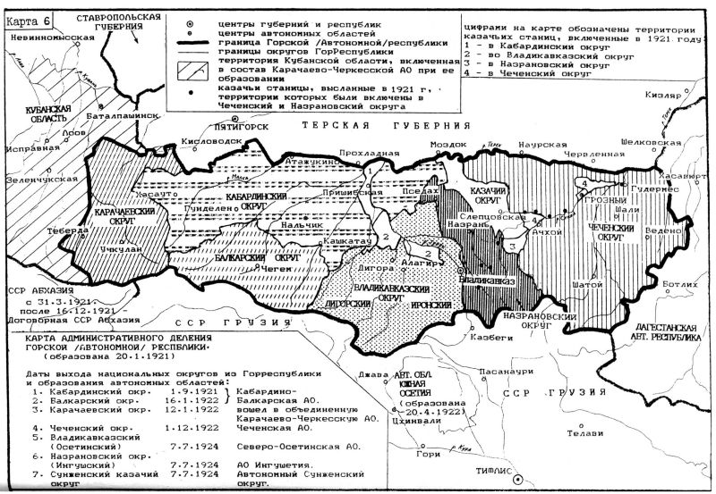
- http://www.iriston.com/nogbon/pictures/Tabol/cuciev_karta_6.jpg - map of Soviet Caucasus in 1922, created by Tsutsiev A.A, which show Mountain Autonomous Soviet Socialist Republic and South Ossetian Autonomous Oblast.
ファイルの履歴
過去の版のファイルを表示するには、その版の日時をクリックしてください。
| 日付と時刻 | サムネイル | 寸法 | 利用者 | コメント | |
|---|---|---|---|---|---|
| 現在の版 | 2015年12月26日 (土) 17:03 | | 1,613 × 1,152 (127キロバイト) | PANONIAN | Reverted to version as of 14:47, 27 March 2010 (UTC) - please upload your version under different filename |
| 2015年12月26日 (土) 10:56 |  | 1,613 × 1,090 (115キロバイト) | Ercwlff | corrected georgian city names | |
| 2015年12月26日 (土) 10:45 |  | 1,613 × 1,090 (114キロバイト) | Ercwlff | corrected | |
| 2015年12月26日 (土) 10:42 |  | 1,613 × 1,090 (117キロバイト) | Ercwlff | ~~~~ | |
| 2010年3月27日 (土) 14:47 |  | 1,613 × 1,152 (127キロバイト) | PANONIAN | on the second thought, this map is focused on the history of Ossetians and other north Caucasian peoples and therefore disputes areas claimed by Armenia and Azerbaijan are not very relevant subject here | |
| 2010年3月26日 (金) 22:04 |  | 1,613 × 1,216 (134キロバイト) | PANONIAN | corrected one description | |
| 2010年3月25日 (木) 22:54 |  | 1,613 × 1,216 (132キロバイト) | PANONIAN | new version | |
| 2010年3月23日 (火) 23:52 |  | 1,613 × 1,122 (121キロバイト) | PANONIAN | correction | |
| 2010年3月23日 (火) 18:51 |  | 1,613 × 1,122 (121キロバイト) | PANONIAN | significant improvement - I hope that this is a final version | |
| 2010年3月23日 (火) 16:32 |  | 1,227 × 915 (88キロバイト) | PANONIAN | corrections |
ファイルの使用状況
以下の 4 ページがこのファイルを使用しています:
グローバルなファイル使用状況
以下に挙げる他のウィキがこの画像を使っています:
- ar.wikipedia.org での使用状況
- ast.wikipedia.org での使用状況
- bg.wikipedia.org での使用状況
- bn.wikipedia.org での使用状況
- br.wikipedia.org での使用状況
- ca.wikipedia.org での使用状況
- ce.wikipedia.org での使用状況
- de.wikipedia.org での使用状況
- en.wikipedia.org での使用状況
- eo.wikipedia.org での使用状況
- es.wikipedia.org での使用状況
- et.wikipedia.org での使用状況
- fi.wikipedia.org での使用状況
- fr.wikipedia.org での使用状況
- it.wikipedia.org での使用状況
- kk.wikipedia.org での使用状況
- ko.wikipedia.org での使用状況
- ku.wikipedia.org での使用状況
- lt.wikipedia.org での使用状況
- lv.wikipedia.org での使用状況
- mk.wikipedia.org での使用状況
- no.wikipedia.org での使用状況
- os.wikipedia.org での使用状況
- pl.wikipedia.org での使用状況
- pnb.wikipedia.org での使用状況
このファイルのグローバル使用状況を表示する。