
ファイル:Shameen Canton.jpg

このプレビューのサイズ: 800 × 375 ピクセル。 その他の解像度: 320 × 150 ピクセル | 640 × 300 ピクセル | 1,024 × 480 ピクセル | 1,280 × 600 ピクセル | 2,560 × 1,200 ピクセル | 11,584 × 5,430 ピクセル。
元のファイル (11,584 × 5,430 ピクセル、ファイルサイズ: 10.84メガバイト、MIME タイプ: image/jpeg)
ウィキメディア・コモンズのファイルページにある説明を、以下に表示します。
|
| 警告 | この画像を最大解像度で表示する際に、一部のブラウザで問題が起きることがあります。この画像は画素数が非常に大きいため、正しく読み込まれなかったりブラウザがフリーズしたりする可能性があります。 |
|---|
概要
| 解説 |
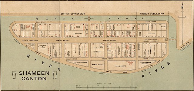
English: Cadastral map of Shameen [i.e. Shamian Island] in Canton [i.e. Guangzhou]. It is one mile in circumference and lies just off Canton, which has always been a center of commerce, competing with Hong Kong, only sixty miles away. Because the island was a British and French Concession, it was carefully patrolled and connected to the mainland on the northern side by the carefully-guarded "English Bridge" and a French Bridge on the eastern side. The larger western part was English and the eastern part French. Each had its own municipal offices, even its own police forces, Sikhs for the British, Annamites for the French. The map shows in detail the use of the offices and buildings on the island. 中文(繁體):廣州市沙面島的地圖,使用粵音「Shameen」標註。藏於澳洲國家圖書館。 |
| 日付 | 1920年と1929年の間 |
| 原典 | http://nla.gov.au/nla.map-brsc67 |
| 作者 | 不明 |
ライセンス
|
この著作物は、著作権の保護期間が著作者の死後70年以下である国・地域においてパブリックドメインの状態にあります。
| |
| このファイルは著作権法の既知の制約(隣接権や関連する権利を含む)から自由であると特定されています。 | |
| 注釈 | この画像には注釈がついています: コモンズで注釈を見る |
ファイルの履歴
過去の版のファイルを表示するには、その版の日時をクリックしてください。
| 日付と時刻 | サムネイル | 寸法 | 利用者 | コメント | |
|---|---|---|---|---|---|
| 現在の版 | 2018年1月19日 (金) 05:59 | | 11,584 × 5,430 (10.84メガバイト) | User-duck | Cropped using CropTool with lossless mode. |
| 2013年2月26日 (火) 09:35 |  | 11,984 × 5,952 (12メガバイト) | Gzdavidwong | User created page with UploadWizard |
ファイルの使用状況
以下のページがこのファイルを使用しています:
グローバルなファイル使用状況
以下に挙げる他のウィキがこの画像を使っています:
- en.wikipedia.org での使用状況
- fr.wikipedia.org での使用状況
- it.wikipedia.org での使用状況
- no.wikipedia.org での使用状況
- pt.wikipedia.org での使用状況
- ru.wikipedia.org での使用状況
- tr.wikipedia.org での使用状況
- vi.wikipedia.org での使用状況
- zh-yue.wikipedia.org での使用状況
- zh.wikipedia.org での使用状況