
ファイル:Rockall EEZ map-en.svg

この SVG ファイルのこの PNG プレビューのサイズ: 455 × 600 ピクセル. その他の解像度: 182 × 240 ピクセル | 364 × 480 ピクセル | 583 × 768 ピクセル | 777 × 1,024 ピクセル | 1,554 × 2,048 ピクセル | 1,904 × 2,509 ピクセル。
元のファイル (SVG ファイル、1,904 × 2,509 ピクセル、ファイルサイズ: 577キロバイト)
ウィキメディア・コモンズのファイルページにある説明を、以下に表示します。
|
概要
| 解説 |
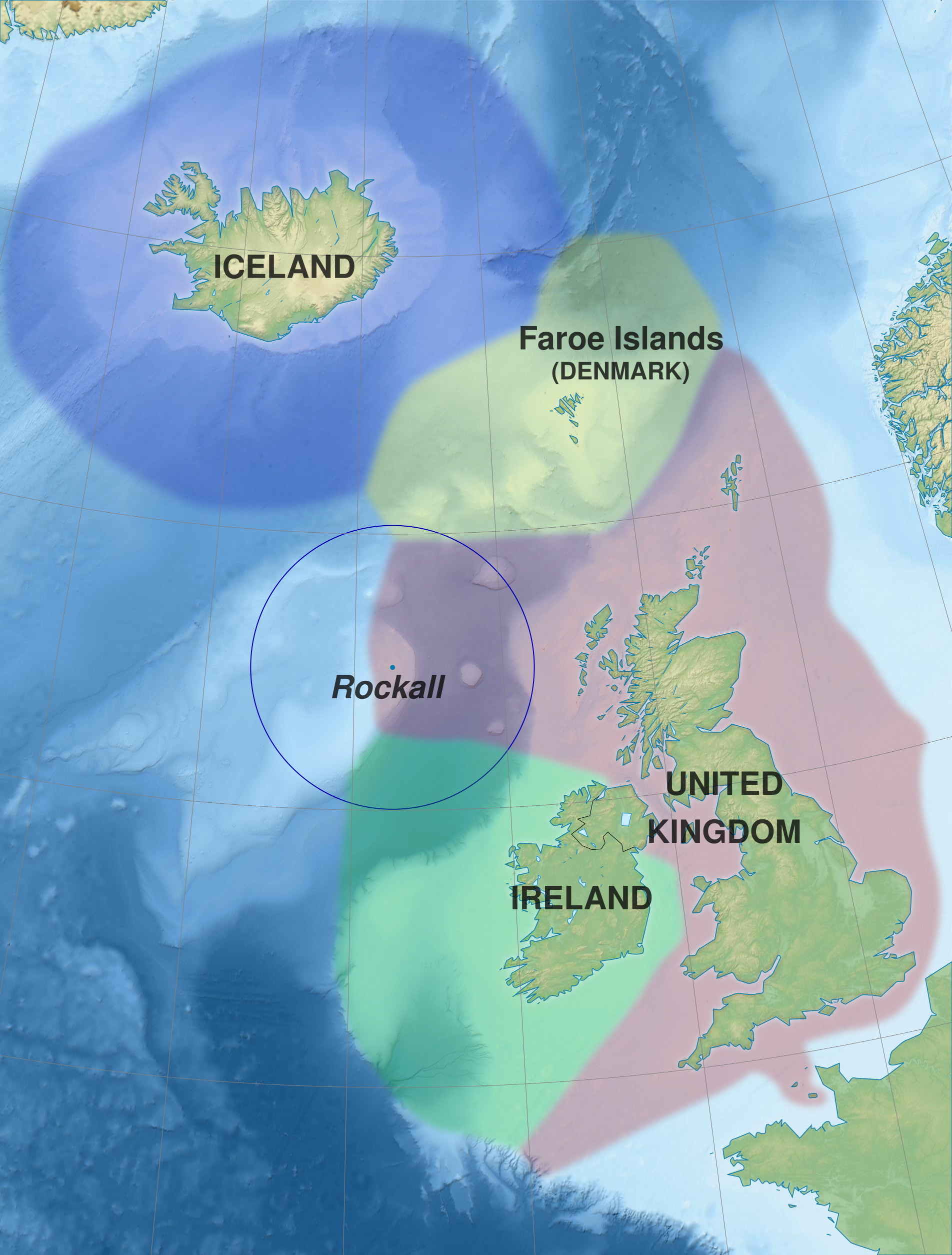
English: Map of exclusive economic zones of the UK, Republic of Ireland, the Faroe Islands (Denmark) and Iceland around Rockall, United Kingdom. Cartographic data :
Français : Carte des zones économiques exclusives du Royaume-Uni, de l'Irlande, des îles Féroé (Danemark) et de l'Islande autour de Rockall (Royaume-Uni). Données cartographiques :
|
||||
| 日付 | (UTC) | ||||
| 原典 |
このファイルの派生元: Rockall EEZ map-fr.svg |
||||
| 作者 | Sémhur (talk) | ||||
| 許可 (ファイルの再利用) |
|||||
| 帰属 (ライセンスによる要求事項) | © Sémhur / Wikimedia Commons / | ||||
| SVG | W3C-validity not checked.
|
||||
| Graphic Lab | |||||
| その他のバージョン |
|

| カメラの位置 | | 以下のサービスでこの位置を確認する: オープンストリートマップ |
|---|
ライセンス
この作品の著作権者である私は、この作品を以下のライセンスで提供します。
| コピーレフト: この芸術作品はフリーです。あなたは、自由芸術ライセンスの規約に従うことで、再配布や改変が可能です。このライセンスの見本は、Copyleft Attitude または他のウェブサイトで見ることができます。 |
This file is licensed under the Creative Commons Attribution-Share Alike Attribution-Share Alike 4.0 International, 3.0 Unported, 2.5 Generic, 2.0 Generic and 1.0 Generic license.
- あなたは以下の条件に従う場合に限り、自由に
- 共有 – 本作品を複製、頒布、展示、実演できます。
- 再構成 – 二次的著作物を作成できます。
- あなたの従うべき条件は以下の通りです。
- 表示 – あなたは適切なクレジットを表示し、ライセンスへのリンクを提供し、変更があったらその旨を示さなければなりません。これらは合理的であればどのような方法で行っても構いませんが、許諾者があなたやあなたの利用行為を支持していると示唆するような方法は除きます。
- 継承 – もしあなたがこの作品をリミックスしたり、改変したり、加工した場合には、あなたはあなたの貢献部分を元の作品とこれと同一または互換性があるライセンスの下に頒布しなければなりません。
あなたは上記のライセンスから、どれか一つ以上を選択できます。
元のアップロードログ
This image is a derivative work of the following images:
- File:Rockall_EEZ_map-fr.svg licensed with Cc-by-sa-3.0,2.5,2.0,1.0, FAL
- 2012-02-20T21:13:22Z Sémhur 512x675 (590717 Bytes) La ZEE des îles Anglo-normandes rejoint celle de la Grande-Bretagne.
- 2012-02-20T20:52:35Z Sémhur 512x675 (590896 Bytes) + Metadata
- 2012-02-20T20:46:34Z Sémhur 512x675 (589169 Bytes) == {{int:filedesc}} == {{Information |Description={{Multilingual description |en= Map of exclusive economic zones around [[:en:Rockall|]], United Kingdom. |fr= Carte des zones économiques exclusives autour de [[:fr:Rockall|]
Uploaded with derivativeFX
ファイルの履歴
過去の版のファイルを表示するには、その版の日時をクリックしてください。
| 日付と時刻 | サムネイル | 寸法 | 利用者 | コメント | |
|---|---|---|---|---|---|
| 現在の版 | 2014年5月30日 (金) 09:52 | | 1,904 × 2,509 (577キロバイト) | Sémhur | Valid SVG |
| 2012年2月21日 (火) 13:32 |  | 512 × 675 (577キロバイト) | Sémhur | == {{int:filedesc}} == {{Information |Description={{Multilingual description |en= Map of exclusive economic zones of the UK, Republic of Ireland, the Faroe Islands (Denmark) and Iceland around Rockall, Uni |
ファイルの使用状況
以下のページがこのファイルを使用しています:
グローバルなファイル使用状況
以下に挙げる他のウィキがこの画像を使っています:
- ast.wikipedia.org での使用状況
- da.wikipedia.org での使用状況
- en.wikipedia.org での使用状況
- eo.wikipedia.org での使用状況
- es.wikipedia.org での使用状況
- fr.wikipedia.org での使用状況
- hu.wikipedia.org での使用状況
- no.wikipedia.org での使用状況
- pl.wikipedia.org での使用状況
- sv.wikipedia.org での使用状況
- szl.wikipedia.org での使用状況
- tr.wikipedia.org での使用状況
- zh.wikipedia.org での使用状況