
ファイル:Northern Mariana Islands map.gif
高解像度版はありません。
Northern_Mariana_Islands_map.gif (345 × 371 ピクセル、ファイルサイズ: 24キロバイト、MIME タイプ: image/gif)
ウィキメディア・コモンズのファイルページにある説明を、以下に表示します。
|
概要
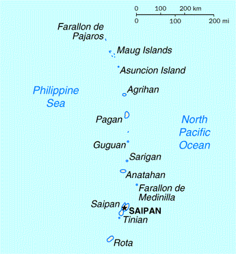
| 解説 | Map of the Northern Mariana Islands |
| 原典 | http://www.doi.gov/oia/Islandpages/cnmipage.htm |
| 作者 | United States Department of the Interior |
ライセンス
| This image or media file contains material based on a work of a United States Department of the Interior employee, created as part of that person's official duties. As a work of the U.S. federal government, such work is in the public domain in the United States. See the Department of the Interior copyright policy for more information. |  |
ファイルの履歴
過去の版のファイルを表示するには、その版の日時をクリックしてください。
| 日付と時刻 | サムネイル | 寸法 | 利用者 | コメント | |
|---|---|---|---|---|---|
| 現在の版 | 2010年8月18日 (水) 03:17 | | 345 × 371 (24キロバイト) | Ras67 | cropped |
| 2008年5月17日 (土) 00:24 |  | 351 × 377 (25キロバイト) | Scanlan | {{Information |Description=Map of the Northern Mariana Islands |Source=http://www.doi.gov/oia/Islandpages/cnmipage.htm |Date= |Author=United States Department of the Interior |Permission= |other_versions= }} [[Category:Maps of the Northern Marian |
ファイルの使用状況
以下のページがこのファイルを使用しています:
グローバルなファイル使用状況
以下に挙げる他のウィキがこの画像を使っています:
- af.wikipedia.org での使用状況
- ar.wikipedia.org での使用状況
- ast.wikipedia.org での使用状況
- be-tarask.wikipedia.org での使用状況
- bn.wikipedia.org での使用状況
- ch.wikipedia.org での使用状況
- cs.wikipedia.org での使用状況
- cy.wikipedia.org での使用状況
- da.wikipedia.org での使用状況
- en.wikipedia.org での使用状況
- es.wikipedia.org での使用状況
- fa.wikipedia.org での使用状況
- fr.wikipedia.org での使用状況
- he.wikipedia.org での使用状況
- id.wikipedia.org での使用状況
- incubator.wikimedia.org での使用状況
- io.wikipedia.org での使用状況
- ka.wikipedia.org での使用状況
- ml.wikipedia.org での使用状況
- mr.wikipedia.org での使用状況
- pt.wikipedia.org での使用状況
- ru.wikipedia.org での使用状況
- ta.wikipedia.org での使用状況
- to.wikipedia.org での使用状況
- tr.wiktionary.org での使用状況
- tt.wikipedia.org での使用状況
- uk.wikipedia.org での使用状況