
ファイル:MSH82 st helens spirit lake reflection 05-19-82.jpg

このプレビューのサイズ: 800 × 544 ピクセル。 その他の解像度: 320 × 218 ピクセル | 640 × 435 ピクセル | 1,024 × 697 ピクセル | 1,280 × 871 ピクセル | 2,560 × 1,742 ピクセル | 4,734 × 3,221 ピクセル。
元のファイル (4,734 × 3,221 ピクセル、ファイルサイズ: 1.1メガバイト、MIME タイプ: image/jpeg)
ウィキメディア・コモンズのファイルページにある説明を、以下に表示します。
|
概要
| 解説 |
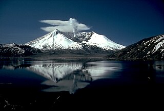
English: Mount St. Helens and the devastated area is now within the 110,000-acre Mount St. Helens National Volcanic Monument, under jurisdiction of the United States Forest Service. Visitor centers, interpretive areas, and trails are being established as thousands of tourists, students, and scientists visit the monument daily. Mount St. Helens is once again considered to be one of the most beautiful and interesting of the Cascade volcanic peaks. |
|||
| 日付 | ||||
| 原典 |
CVO Photo Archives Mount St. Helens, Washington Before, During, and After May 18, 1980 |
|||
| 作者 | Lyn Topinka | |||
| 許可 (ファイルの再利用) |
|
ファイルの履歴
過去の版のファイルを表示するには、その版の日時をクリックしてください。
| 日付と時刻 | サムネイル | 寸法 | 利用者 | コメント | |
|---|---|---|---|---|---|
| 現在の版 | 2007年11月28日 (水) 17:54 | | 4,734 × 3,221 (1.1メガバイト) | CarolSpears | |
| 2005年8月9日 (火) 06:02 |  | 2,935 × 1,996 (832キロバイト) | Complex01 | USGS photo of Mt. Saint Helens. '''Caption''': Mount St. Helens and the devastated area is now within the 110,000-acre Mount St. Helens National Volcanic Monument, under jurisdiction of the United States Forest Service. Visitor centers, interpretive area |
ファイルの使用状況
グローバルなファイル使用状況
以下に挙げる他のウィキがこの画像を使っています:
- ca.wikipedia.org での使用状況
- cs.wikipedia.org での使用状況
- da.wikipedia.org での使用状況
- en.wikipedia.org での使用状況
- en.wikivoyage.org での使用状況
- eo.wikipedia.org での使用状況
- es.wikipedia.org での使用状況
- fi.wikipedia.org での使用状況
- fr.wikipedia.org での使用状況
- fr.wikibooks.org での使用状況
- fr.wikiversity.org での使用状況
- he.wikipedia.org での使用状況
- he.wikivoyage.org での使用状況
- hr.wikipedia.org での使用状況
- hu.wikipedia.org での使用状況
- it.wikipedia.org での使用状況
- no.wikipedia.org での使用状況
- ro.wikipedia.org での使用状況
- sh.wikipedia.org での使用状況
- sk.wikipedia.org での使用状況
- sr.wikipedia.org での使用状況
- sv.wikipedia.org での使用状況
- uk.wikipedia.org での使用状況
- www.wikidata.org での使用状況
- zh.wikipedia.org での使用状況