
ファイル:Jakarta Skyline Part 2.jpg

元のファイル (1,546 × 768 ピクセル、ファイルサイズ: 801キロバイト、MIME タイプ: image/jpeg)
ウィキメディア・コモンズのファイルページにある説明を、以下に表示します。
|

|
Copyright warning: A subject in this image is protected by copyright.
This image features an architectural or artistic work, photographed from a public space in Indonesia. There are no freedom of panorama exceptions of any kind under the Chapter VI (Copyright Limitations), Articles 43–51 of the Indonesian Copyright Act No. 28, 2014, which means that these architectural or artistic works cannot be photographed freely for anything other than non-commercial or personal uses. If a copyrighted architectural or artistic work is contained in this image and it is a substantial reproduction, this photo cannot be licensed under a free license, and will be deleted. Framing this image to focus on the copyrighted work is also a copyright violation. Before reusing this content, ensure that you have the right to do so. You are solely responsible for ensuring that you do not infringe someone else's copyrights. See our general disclaimer for more information. |

概要
| 解説 |
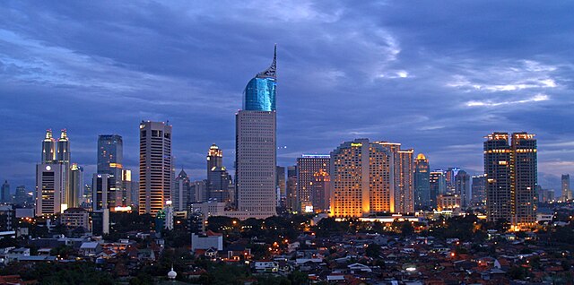
English: Lining up Jakarta's skyscrapers along the CBD with Wisma 46 as the centerpiece.
Wisma 46 is designed by Zeidler Partnership and has been well-known for being Indonesia's tallest building; and Jakarta's most distinguished skyscrapers with its unique shape resembling an elegant fountain pen. Singapore may have a "Durian" (The Esplanade); and Beijing has a "Bird's Nest" (Olympic Stadium) and "Trousers Pants" (CCTV Tower); but Jakarta has an elegant "Fountain Pen". Although it may not be the tallest building in Indonesia now, -with the completion of Menara BCA and The Kempinski Residences at the Grand Indonesia Mall complex; and construction at The Jakarta Tower (558m) is coming soon-, Wisma 46 remains one of the nation's most distinguished and unique building. |
| 日付 | |
| 原典 | https://www.flickr.com/photos/joe-joe/2303992129/ |
| 作者 | yohanes budiyanto |
| 被写体の位置 | | 以下のサービスでこの位置を確認する: オープンストリートマップ |
|---|
ライセンス
- あなたは以下の条件に従う場合に限り、自由に
- 共有 – 本作品を複製、頒布、展示、実演できます。
- 再構成 – 二次的著作物を作成できます。
- あなたの従うべき条件は以下の通りです。
- 表示 – あなたは適切なクレジットを表示し、ライセンスへのリンクを提供し、変更があったらその旨を示さなければなりません。これらは合理的であればどのような方法で行っても構いませんが、許諾者があなたやあなたの利用行為を支持していると示唆するような方法は除きます。
| この画像は当初、yohanes budiyanto によって Flickr の https://www.flickr.com/photos/27228523@N00/2303992129 に投稿されたものです。2009-12-20、FlickreviewR ボットによってレビューされ、cc-by-2.0 のライセンスで提供されていることが確認されました。 |
ファイルの履歴
過去の版のファイルを表示するには、その版の日時をクリックしてください。
| 日付と時刻 | サムネイル | 寸法 | 利用者 | コメント | |
|---|---|---|---|---|---|
| 現在の版 | 2023年5月3日 (水) 21:45 | | 1,546 × 768 (801キロバイト) | B18IDH | Maybe This Is More Correct? |
| 2009年12月19日 (土) 19:05 |  | 906 × 450 (519キロバイト) | Rochelimit | {{Information |Description={{en|1=Lining up Jakarta's skyscrapers. I took similar picture before with my Leica. This time, I tried it with my E-500 when the setting is blue, unlike previously in magenta. I'm also trying the 'golden rule' where the most pr |
ファイルの使用状況
以下のページがこのファイルを使用しています:
グローバルなファイル使用状況
以下に挙げる他のウィキがこの画像を使っています:
- ar.wikipedia.org での使用状況
- arz.wikipedia.org での使用状況
- ast.wikipedia.org での使用状況
- azb.wikipedia.org での使用状況
- ban.wikipedia.org での使用状況
- ba.wikipedia.org での使用状況
- bjn.wikipedia.org での使用状況
- blk.wikipedia.org での使用状況
- bn.wikipedia.org での使用状況
- bn.wikibooks.org での使用状況
- bs.wikipedia.org での使用状況
- bug.wikipedia.org での使用状況
- bxr.wikipedia.org での使用状況
- ceb.wikipedia.org での使用状況
- ckb.wikipedia.org での使用状況
- crh.wikipedia.org での使用状況
- csb.wikipedia.org での使用状況
- cu.wikipedia.org での使用状況
- cy.wikipedia.org での使用状況
- dag.wikipedia.org での使用状況
- de.wikipedia.org での使用状況
- diq.wikipedia.org での使用状況
- dv.wikipedia.org での使用状況
- en.wikipedia.org での使用状況
- en.wikivoyage.org での使用状況
- eo.wikipedia.org での使用状況
- es.wikipedia.org での使用状況
- eu.wikipedia.org での使用状況
- fa.wikipedia.org での使用状況
このファイルのグローバル使用状況を表示する。