
ファイル:Grossglockner from SW.jpg

このプレビューのサイズ: 800 × 600 ピクセル。 その他の解像度: 320 × 240 ピクセル | 640 × 480 ピクセル | 1,024 × 768 ピクセル | 1,280 × 960 ピクセル | 1,884 × 1,413 ピクセル。
元のファイル (1,884 × 1,413 ピクセル、ファイルサイズ: 421キロバイト、MIME タイプ: image/jpeg)
ウィキメディア・コモンズのファイルページにある説明を、以下に表示します。
|
概要
| 解説 |
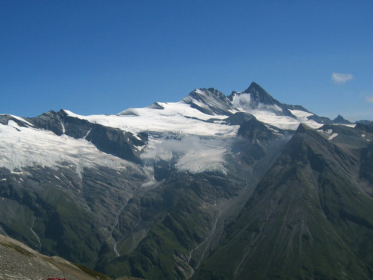
Deutsch: Großglockner vom Südwesten. Der Großglockner (3.797 m) ist der höchste pyramidenförmig erscheinende Gipfel rechts von der Mitte. Der breite großteils schneefreie Berg links davon ist die Glocknerwand (3.722 m) und ihr linker Eckpfeiler Hofmannspitze. Links im Bild ist über einer Felswand (Romariswand) der Romariswandkopf (3.511 m) zu sehen. Der pyramidenförmige Berg im Vordergrund, vor dem Großglockner, ist die Zollspitze (3.024 m).
Der Gletscher vor dem Großglockner ist das Teischnitzkees; rechts oberhalb der Romariswand ist das Fruschnitzkees. Aufnahmeort: Am Silesia Höhenweg, nahe dem Sattel nördlich des Gradötzkogel aufgenommen, in ca. 2.800 m Höhe und in 8 km Entfernung vom Gipfel des Großglockners.English: Großglockner seen from the southwest. The Großglockner (3.797 m), the highest peak of Austria, is the highest peak in the image, pyramid-shaped, right of the center. Left of it, the more elongated and mostly snow-free mountain is the Glocknerwand (3.722 m) with its left pillar Hofmannspitze. The Romariswandkopf (3.511 m) is the peak of the rock wall (Romariswand) in the left part of the image. The pyramid-shaped peak in front of the Großglockner is the Zollspitze (3.024 m). The glacier in front of the Großglockner is the Teischnitzkees, that behind and right of the Romariswand is the Fruschnitzkees. Français : Le Grossglockner vu du sud-ouest. Le Grossglockner (3797 m), est le plus haut sommet d'Autriche. La montage plus allongée et presque libre de neige à sa gauche porte le Glocknerwand (3722 m) et le Hofmannspitze. Tout à gauche, le Romariswandkopf ("Pic du mur de pierre", 3511 m) est visible. Le sommet en forme de pyramide devant le Grossglockner s'appelle Zollspitze (3024 m). Le glacier visible devant le Grossglockner est le Teischnitzkees, celui se trouvant en arrière et à droite du Romariswand, le Fruschnitzkees. |
| 日付 | |
| 原典 | Photo taken by myself, cropped, color balance slightly adjusted. |
| 作者 | Michael Schmid |
| その他のバージョン |

ライセンス
この作品の著作権者である私は、この作品を以下のライセンスで提供します。
このファイルはクリエイティブ・コモンズ 表示-継承 2.0 オーストリアライセンスのもとに利用を許諾されています。
- あなたは以下の条件に従う場合に限り、自由に
- 共有 – 本作品を複製、頒布、展示、実演できます。
- 再構成 – 二次的著作物を作成できます。
- あなたの従うべき条件は以下の通りです。
- 表示 – あなたは適切なクレジットを表示し、ライセンスへのリンクを提供し、変更があったらその旨を示さなければなりません。これらは合理的であればどのような方法で行っても構いませんが、許諾者があなたやあなたの利用行為を支持していると示唆するような方法は除きます。
- 継承 – もしあなたがこの作品をリミックスしたり、改変したり、加工した場合には、あなたはあなたの貢献部分を元の作品とこれと同一または互換性があるライセンスの下に頒布しなければなりません。

|
|
ファイルの履歴
過去の版のファイルを表示するには、その版の日時をクリックしてください。
| 日付と時刻 | サムネイル | 寸法 | 利用者 | コメント | |
|---|---|---|---|---|---|
| 現在の版 | 2005年7月10日 (日) 18:04 | | 1,884 × 1,413 (421キロバイト) | Schmid | {{Information |Description = Großglockner seen from the southwest | Source = Photo taken by myself, cropped, color balance slightly adjusted. | Date = 2003-Jul-30 | Author = Michael Schmid | Permission = Michael Schmid put |
ファイルの使用状況
以下のページがこのファイルを使用しています:
グローバルなファイル使用状況
以下に挙げる他のウィキがこの画像を使っています:
- an.wikipedia.org での使用状況
- ar.wikipedia.org での使用状況
- bg.wikipedia.org での使用状況
- bn.wikipedia.org での使用状況
- bn.wikibooks.org での使用状況
- bs.wikipedia.org での使用状況
- ca.wikipedia.org での使用状況
- cs.wikipedia.org での使用状況
- Rakousko
- Großglockner
- Karavanky
- Totes Gebirge
- Ennstalské Alpy
- Vysoké Taury
- Nízké Taury
- Hory Solné komory
- Dachstein
- Rakouské Alpy
- Zillertalské Alpy
- Ötztalské Alpy
- Stubaiské Alpy
- Gailtalské Alpy
- Steinberge
- Hochschwab
- Rax
- Berchtesgadenské Alpy
- Vídeňský les
- Gutensteinské Alpy
- Türnitzské Alpy
- Mürzstegské Alpy
- Ybbstalské Alpy
- Hornorakouské předhůří
- Tennengebirge
- Dientener Berge
- Kaisergebirge
- Chiemgauské Alpy
- Rofan
- Karwendel
- Nockberge
- Wetterstein
- Lechtalské Alpy
- Verwall
- Lechquellengebirge
- Bregenzský les (pohoří)
- Algavské Alpy
- Lavanttalské Alpy
- Villgratenské hory
- Kitzbühelské Alpy
- Tuxské Alpy
- Silvretta
このファイルのグローバル使用状況を表示する。