
ファイル:Forests and fields distribution map in The Korean Peninsura.jpg
このプレビューのサイズ: 344 × 598 ピクセル。 その他の解像度: 138 × 240 ピクセル | 276 × 480 ピクセル | 441 × 768 ピクセル | 588 × 1,024 ピクセル | 1,766 × 3,072 ピクセル。
元のファイル (1,766 × 3,072 ピクセル、ファイルサイズ: 576キロバイト、MIME タイプ: image/jpeg)
ウィキメディア・コモンズのファイルページにある説明を、以下に表示します。
|
概要
| 解説 |
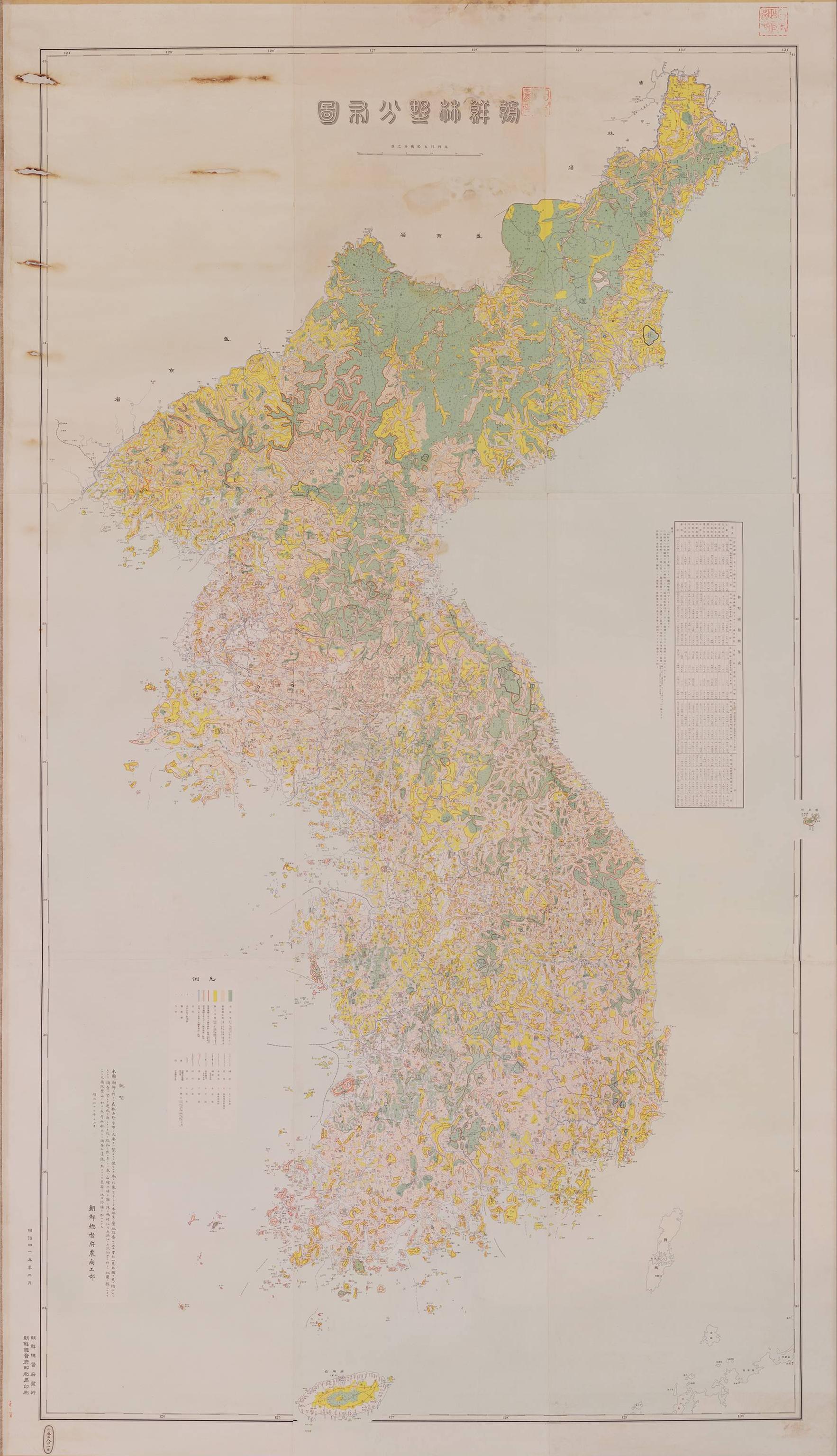
English: A map of the distribution of forests and fields in Japanese-occupied Korea in 1912. Green: Forest land, the density of standing trees is 1 and the density is 0.1 or more. Pink: A place where saplings occur, a place where sickles can be cut with a sickle, and a density of 0.1 or more. Yellow: Non-standing trees, sparse forests with a density of less than 0.1, sparse saplings or grassy rocks, etc. The scale is in Japanese ri. 12.5% of the original image size. Full size image can be obtained from National Archives of Japan (jaen)
日本語: 1910年頃の朝鮮半島の林野分布図(朝鮮総督府農商工部作成)。緑色:成林地、立木の密度完全なる物を1としその0.1以上を有するもの。桃色:稚樹発生地、鎌にて刈りうる程度の稚樹発生地にして密度0.1以上のもの。黄色:無立木地、密度0.1未満の疎林地及稚樹疎生地又は草生地岩石地等。 |
| 日付 |
English: 1912 (45th year of Meiji) 日本語: 1912年、明治45年 |
| 原典 | 朝鮮林野分布図、ja:国立公文書館デジタル・ギャラリー Forests and fields distribution map in The Korean Peninsula, Digital Gallery, en:National Archives of Japan |
| 作者 |
English: The Agriculture, Commerce and industry Division of the Korea-Governor's General Office 日本語: 朝鮮総督府農商工部 |
ライセンス
|
このファイルは、パブリックドメインの状態にある平面的な美術の著作物を写真術によって忠実に複製したものです。このような複製はアメリカ合衆国においてパブリックドメインの状態にあります。その他の地域では再利用に制限がかかる場合があります。詳しくはReuse of PD-Art photographsをご覧ください。美術の著作物としての原図は、次の理由によりパブリックドメインの状態にあります。
| ||||
| 注釈 | この画像には注釈がついています: コモンズで注釈を見る |
ファイルの履歴
過去の版のファイルを表示するには、その版の日時をクリックしてください。
| 日付と時刻 | サムネイル | 寸法 | 利用者 | コメント | |
|---|---|---|---|---|---|
| 現在の版 | 2009年9月13日 (日) 21:38 | | 1,766 × 3,072 (576キロバイト) | Jjok | {{Information |Description={{en|1=12.5% of the original image size. Full size image can be obtained from National Archives of Japan ([http://jpimg.digital.archives.go.jp/kouseisai/category/ezu/chousen_rinya.html ja][http://jpimg.digital.archives.go.jp/kou |
ファイルの使用状況
以下のページがこのファイルを使用しています: