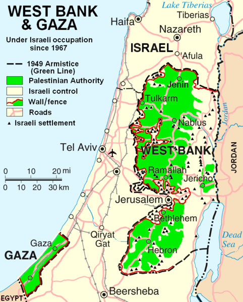
ファイル:West Bank & Gaza Map 2007 (Settlements).png

このプレビューのサイズ: 482 × 599 ピクセル。 その他の解像度: 193 × 240 ピクセル | 386 × 480 ピクセル | 780 × 970 ピクセル。
元のファイル (780 × 970 ピクセル、ファイルサイズ: 86キロバイト、MIME タイプ: image/png)
ファイルの履歴
過去の版のファイルを表示するには、その版の日時をクリックしてください。
| 日付と時刻 | サムネイル | 寸法 | 利用者 | コメント | |
|---|---|---|---|---|---|
| 現在の版 | 2013年10月29日 (火) 22:55 |  | 780 × 970 (86キロバイト) | Scott | Correct capitalization in legend. |
| 2013年10月29日 (火) 22:54 |  | 780 × 970 (86キロバイト) | Scott | Correct capitalization in legend. | |
| 2009年1月12日 (月) 06:21 |  | 780 × 970 (105キロバイト) | HowardMorland | Replace .gif file with identical .png file <!--{{ImageUpload|basic}}--> |
ファイルの使用状況
以下の 3 ページがこのファイルを使用しています:
グローバルなファイル使用状況
以下に挙げる他のウィキがこの画像を使っています:
- am.wikipedia.org での使用状況
- ar.wikipedia.org での使用状況
- ast.wikipedia.org での使用状況
- azb.wikipedia.org での使用状況
- bg.wikipedia.org での使用状況
- ca.wikipedia.org での使用状況
- ckb.wikipedia.org での使用状況
- cs.wikipedia.org での使用状況
- cy.wikipedia.org での使用状況
- da.wikipedia.org での使用状況
- de.wikipedia.org での使用状況
- de.wikinews.org での使用状況
- de.wikivoyage.org での使用状況
- en.wikipedia.org での使用状況
- Talk:List of ongoing armed conflicts
- User:Timeshifter/Userboxes
- User:Gimmetrow/test
- User:Gimmetrow/test2
- User:Keizers
- Talk:Jerusalem/Archive 15
- Talk:Palestinian Authority/Archive 2
- Wikipedia:Top 25 Report/July 13 to 19, 2014
- Wikipedia:Top 25 Report/July 20 to 26, 2014
- Wikipedia:Top 25 Report/July 27 to August 2, 2014
- Talk:State of Palestine/Archive 12
- User:Timeshifter/Userboxes/Palestine: Peace Not Apartheid. By Jimmy Carter
- User:Dare2Leap/info
- User:Timeshifter/Archive 2
- Wikipedia talk:WikiProject Israel Palestine Collaboration/Archive 9
- en.wikinews.org での使用状況
- eo.wikipedia.org での使用状況
- es.wikipedia.org での使用状況
- eu.wikipedia.org での使用状況
- fa.wikipedia.org での使用状況
- fi.wikipedia.org での使用状況
- fo.wikipedia.org での使用状況
- fr.wikipedia.org での使用状況
このファイルのグローバル使用状況を表示する。
