
ファイル:Uganda Protectorate British administration.png

このプレビューのサイズ: 528 × 600 ピクセル。 その他の解像度: 211 × 240 ピクセル | 422 × 480 ピクセル | 661 × 751 ピクセル。
元のファイル (661 × 751 ピクセル、ファイルサイズ: 18キロバイト、MIME タイプ: image/png)
ウィキメディア・コモンズのファイルページにある説明を、以下に表示します。
|
概要
| 解説 |
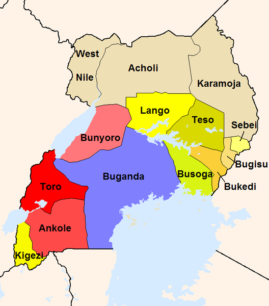
English: The map shows the British administration units in the Uganda Protectorate (borders of 1926).
The reddish areas and the blue Buganda are areas, where traditional kingdoms were maintained. In the yellowish areas Baganda-type administration was introduced. The khaki areas had no sole traditional rule before. |
| 原典 |
投稿者自身による著作物
|
| 作者 | Slomox |
ライセンス
| この著作物の著作権者である私は、この著作物における権利を放棄しパブリックドメインとします。これは全世界で適用されます。 一部の国では、これが法的に可能ではない場合があります。その場合は、次のように宣言します。 私は、あらゆる人に対して、法により必要とされている条件を除き、如何なる条件も課すことなく、あらゆる目的のためにこの著作物を使用する権利を与えます。 |
ファイルの履歴
過去の版のファイルを表示するには、その版の日時をクリックしてください。
| 日付と時刻 | サムネイル | 寸法 | 利用者 | コメント | |
|---|---|---|---|---|---|
| 現在の版 | 2008年2月22日 (金) 00:44 | | 661 × 751 (18キロバイト) | Mahahahaneapneap | pngcrushed |
| 2005年9月18日 (日) 20:34 |  | 661 × 751 (34キロバイト) | Slomox | little correction | |
| 2005年9月18日 (日) 19:36 |  | 661 × 751 (33キロバイト) | Slomox | The map shows the British administration units in the Uganda Protectorate (borders of 1926). The map is based on data given in ''A History of East Africa'' by Odhiambo, Ouso and Williams. The reddish areas and the blue Buganda are areas, where traditiona |
ファイルの使用状況
以下の 4 ページがこのファイルを使用しています:
グローバルなファイル使用状況
以下に挙げる他のウィキがこの画像を使っています:
- als.wikipedia.org での使用状況
- de.wikipedia.org での使用状況
- en.wikipedia.org での使用状況
- es.wikipedia.org での使用状況
- fr.wikipedia.org での使用状況
- io.wikipedia.org での使用状況
- it.wikipedia.org での使用状況
- lt.wikipedia.org での使用状況
- no.wikipedia.org での使用状況
- pt.wikipedia.org での使用状況
- ru.wikipedia.org での使用状況
- uk.wikipedia.org での使用状況
- vec.wikipedia.org での使用状況