
ファイル:Thessaloniki Prefecture, Greece - political map - low detail - numbered.svg

この SVG ファイルのこの PNG プレビューのサイズ: 800 × 566 ピクセル. その他の解像度: 320 × 226 ピクセル | 640 × 453 ピクセル | 1,024 × 724 ピクセル | 1,280 × 905 ピクセル | 2,560 × 1,810 ピクセル | 1,052 × 744 ピクセル。
元のファイル (SVG ファイル、1,052 × 744 ピクセル、ファイルサイズ: 368キロバイト)
ウィキメディア・コモンズのファイルページにある説明を、以下に表示します。
|
概要
| 解説 |
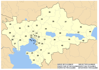
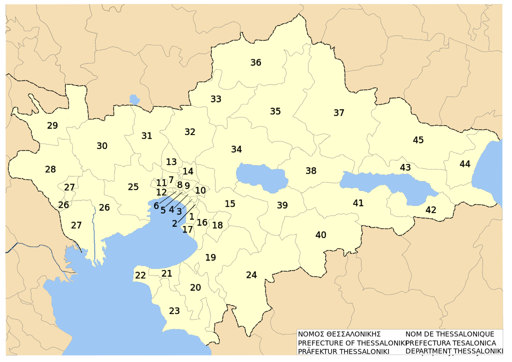
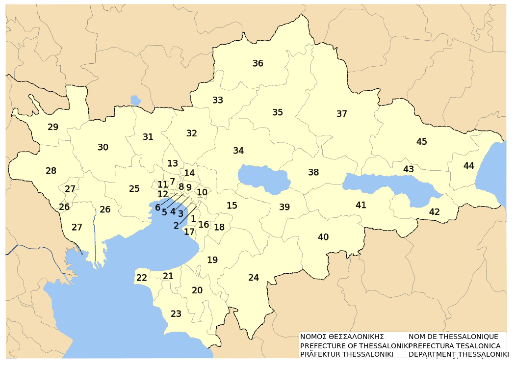
English: w:en:Thessaloniki prefecture, w:en:Greece. Low-detail political map on dimos level. With Numbers.
Deutsch: Präfektur w:de:Thessaloniki (Präfektur), w:de:Griechenland. Niedrig-detaillierte politische Karte auf Ebene der Gemeinden. Nummeriert.
Ellinika: w:el:Νομός Θεσσαλονίκης, w:el:Ελλάδα. Πολιτικός χάρτης με νουμέρα.Ευρετήριο - Index 1 - Δήμος Θεσσαλονίκης - Thessaloniki (Dimos/Municipality) 2 - Δήμος Τριανδρίας - Triandria (Dimos/Municipality) 3 - Δήμος Αγίου Παύλου - Agios Pavlos (Dimos/Municipality) 4 - Δήμος Συκεών - Sykies (Dimos/Municipality) 5 - Δήμος Αμπελοκήπων - Ambelokipi (Dimos/Municipality) 6 - Δήμος Νεαπόλεως - Neapoli (Dimos/Municipality) 7 - Δήμος Ευόσμου - Evosmos (Dimos/Municipality) 8 - Δήμος Σταυρουπόλεως - Stavroupoli (Dimos/Municipality) 9 - Δήμος Πολίχνης - Polichni (Dimos/Municipality) 10 - Κοινότητα Πεύκων - Pefka (Kinotita/Community) 11 - Δήμος Ελευθερίου-Κορδελιού - Eleftherio-Kordelio (Dimos/Municipality) 12 - Δήμος Μενεμένης - Menemeni (Dimos/Municipality) 13 - Δήμος Ωραιοκάστρου - Oreokastro (Dimos/Municipality) 14 - Κοινότητα Ευκαρπίας - Efkarpia (Kinotita/Community) 15 - Δήμος Χορτιάτη - Chortiatis (Dimos/Municipality) 16 - Δήμος Πυλαίας - Pylea (Dimos/Municipality) 17 - Δήμος Καλαμαριάς - Kalamaria (Dimos/Municipality) 18 - Δήμος Πανοράματος - Panorama (Dimos/Municipality) 19 - Δήμος Θέρμης - Thermi (Dimos/Municipality) 20 - Δήμος Μίκρας - Mikra (Dimos/Municipality) 21 - Δήμος Θερμαϊκού - Thermaikos (Dimos/Municipality) 22 - Δήμος Μηχανιώνας - Michaniona (Dimos/Municipality) 23 - Δήμος Επανομής - Epanomi (Dimos/Municipality) 24 - Δήμος Βασιλικών - Vasilika (Dimos/Municipality) 25 - Δήμος Εχεδώρου - Echedoros (Dimos/Municipality) 26 - Δήμος Χαλάστρας - Chalastra (Dimos/Municipality) 27 - Δήμος Αξιού - Axios (Dimos/Municipality) 28 - Δήμος Χαλκηδόνος - Chalkidona (Dimos/Municipality) 29 - Δήμος Κουφαλίων - Koufalia (Dimos/Municipality) 30 - Δήμος Αγίου Αθανασίου - Agios Athanasios (Dimos/Municipality) 31 - Δήμος Καλλιθέας - Kallithea (Dimos/Municipality) 32 - Δήμος Μυγδονίας - Mygdonia (Dimos/Municipality) 33 - Δήμος Ασσήρου - Assiros (Dimos/Municipality) 34 - Δήμος Λαγκαδά - Langadas (Dimos/Municipality) 35 - Δήμος Βερτίσκου - Vertsikos (Dimos/Municipality) 36 - Δήμος Λαχανά - Lachanas (Dimos/Municipality) 37 - Δήμος Σοχού - Sochos (Dimos/Municipality) 38 - Δήμος Εγνατίας - Egnatia (Dimos/Municipality) 39 - Δήμος Κορώνειας - Koronia (Dimos/Municipality) 40 - Δήμος Καλλινδοίων - Kallindia (Dimos/Municipality) 41 - Δήμος Απολλωνίας - Apollonia (Dimos/Municipality) 42 - Δήμος Μαδύτου - Madytos (Dimos/Municipality) 43 - Δήμος Ρεντίνας - Rendina (Dimos/Municipality) 44 - Δήμος Αγίου Γεωργίου - Agios Georgios (Dimos/Municipality) 45 - Δήμος Αρέθουσας - Arethousa (Dimos/Municipality) |
| 日付 | |
| 原典 | self-made after specimen to be found at Official political map of municipalities and municipal districts of Thessaloniki prefecture. Published by Prefecture's administration. Accessed on 2007-08-30 |
| 作者 | Christaras A |
| その他のバージョン |
このファイルの派生的著作物: |
ライセンス
この作品の著作権者である私は、この作品を以下のライセンスで提供します。

|
この文書は、フリーソフトウェア財団発行のGNUフリー文書利用許諾書 (GNU Free Documentation License) 1.2またはそれ以降のバージョンの規約に基づき、複製や再配布、改変が許可されます。不可変更部分、表紙、背表紙はありません。このライセンスの複製は、GNUフリー文書利用許諾書という章に含まれています。 |
このファイルはクリエイティブ・コモンズ 表示 3.0 非移植ライセンスのもとに利用を許諾されています。
- あなたは以下の条件に従う場合に限り、自由に
- 共有 – 本作品を複製、頒布、展示、実演できます。
- 再構成 – 二次的著作物を作成できます。
- あなたの従うべき条件は以下の通りです。
- 表示 – あなたは適切なクレジットを表示し、ライセンスへのリンクを提供し、変更があったらその旨を示さなければなりません。これらは合理的であればどのような方法で行っても構いませんが、許諾者があなたやあなたの利用行為を支持していると示唆するような方法は除きます。
あなたは上記のライセンスから、どれか一つ以上を選択できます。
ファイルの履歴
過去の版のファイルを表示するには、その版の日時をクリックしてください。
| 日付と時刻 | サムネイル | 寸法 | 利用者 | コメント | |
|---|---|---|---|---|---|
| 現在の版 | 2007年8月31日 (金) 15:55 | | 1,052 × 744 (368キロバイト) | Christaras A | {{Information |Description=English: w:en:Thessaloniki prefecture, w:en:Greece. Low-detail political map on dimos level. With Numbers.<br>Deutsch: Präfektur w:de:Thessaloniki (Präfektur), w:de:Griechenland. Niedrig-detaillierte politische |
| 2007年8月31日 (金) 15:24 |  | 1,052 × 744 (368キロバイト) | Christaras A | {{Information |Description=English: w:en:Thessaloniki prefecture, w:en:Greece. Low-detail political map on municipality level. Numbered.<br>Deutsch: Präfektur w:de:Thessaloniki (Präfektur), w:de:Griechenland. Niedrig-detaillierte politis | |
| 2007年8月31日 (金) 15:06 |  | 1,052 × 744 (365キロバイト) | Christaras A | {{Information |Description=English: w:en:Thessaloniki prefecture, w:en:Greece. Low-detail political map on dimos level. With Numbers.<br>Deutsch: Präfektur w:de:Thessaloniki (Präfektur), w:de:Griechenland. Niedrig-detaillierte politische |
ファイルの使用状況
以下のページがこのファイルを使用しています:
グローバルなファイル使用状況
以下に挙げる他のウィキがこの画像を使っています:
- el.wikipedia.org での使用状況
- hr.wikipedia.org での使用状況
- it.wikipedia.org での使用状況
- la.wikipedia.org での使用状況
- lt.wikipedia.org での使用状況