
ファイル:Superpower map 1945.png

このプレビューのサイズ: 800 × 351 ピクセル。 その他の解像度: 320 × 140 ピクセル | 640 × 281 ピクセル | 1,425 × 625 ピクセル。
元のファイル (1,425 × 625 ピクセル、ファイルサイズ: 23キロバイト、MIME タイプ: image/png)
ウィキメディア・コモンズのファイルページにある説明を、以下に表示します。
|
Legend

|
この地図画像は、ベクターイメージである SVG ファイルとして再作成されるべきです。これにはいくつかの利点があります。詳しくはCommons:Media for cleanupを参照してください。この画像の SVG 形式がすでに利用可能である場合は、アップロードしてください。アップロード後、この画像にあるこのテンプレートを{{Vector version available|新しい画像ファイル名.svg}}テンプレートで置き換えてください。
|
English:
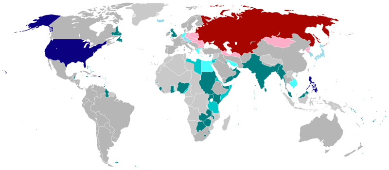
English (en): Map of the world in 1945 with dependencies in lighter shading and respective superpowers at the time.
British Trust Territories
British Postwar Occupations
US postwar Occupations
Soviet postwar Occupations
বাংলা :
বাংলা (bn): ১৯৪৫ সালের মানচিত্রে পরাশক্তি ও তাদের উপর নির্ভর রাষ্ট্রসমূহ
ব্রিটিশ সাম্রাজ্য
ব্রিটিশদের বিশ্বস্ত অঞ্চলসমূহ
যুক্তরাষ্ট্র
যুক্তরাষ্ট্র বিশ্বস্ত অঞ্চলসমুহ
সোভিয়েত ইউনিয়ন
| この著作物は、著作者である英語版ウィキペディアのprojectnameさんによって権利が放棄され、パブリックドメインとされました。これは全世界で適用されます。 一部の国では、これが法的に可能ではない場合があります。その場合は、次のように宣言します。 projectnameは、あらゆる人に対して、法により必要とされている条件を除き、如何なる条件も課すことなく、あらゆる目的のためにこの著作物を使用する権利を与えます。 |
.
ファイルの履歴
過去の版のファイルを表示するには、その版の日時をクリックしてください。
| 日付と時刻 | サムネイル | 寸法 | 利用者 | コメント | |
|---|---|---|---|---|---|
| 現在の版 | 2020年10月19日 (月) 01:25 | | 1,425 × 625 (23キロバイト) | RickoTroanman22 | Fixed Hong Kong, also Tibet did not claim Inner Tibet. |
| 2019年1月6日 (日) 22:22 |  | 1,425 × 625 (39キロバイト) | BMacZero | colored most Aleutian Islands as United States | |
| 2017年7月2日 (日) 14:41 |  | 1,425 × 625 (39キロバイト) | Fireinacrowdedtheatre | Changed New Zealand to grey; the majority-white Dominions were not under British control by 1945 (except Newfoundland). Also added Soviet occupation of central Europe and Mongolia, British occupation of Greece, American occupation of Iceland, and the B... | |
| 2014年10月7日 (火) 23:11 |  | 1,425 × 625 (43キロバイト) | ZaidRock11 | Added post-World War II occupations in 1945 (Germany, Austria, Korea, Japan, Kwantung, Indochina); New Zealand did get full independence until 1947. | |
| 2013年6月9日 (日) 07:41 |  | 1,425 × 625 (36キロバイト) | Elmor | Germany occupation zones+Saar | |
| 2012年2月10日 (金) 00:11 |  | 1,425 × 625 (51キロバイト) | Quintucket | Reverted to version as of 17:28, 20 August 2011 I missed the addition of Trust territories | |
| 2012年1月28日 (土) 07:14 |  | 1,357 × 628 (52キロバイト) | Quintucket | Reverted to version as of 21:44, 27 June 2007 Like User:Swarm said, India and the Philippines were still colonies at the time. Belarus and Ukraine were both UN members, which doesn't mean we should show them as non-USSR | |
| 2011年12月1日 (木) 08:12 |  | 1,425 × 625 (57キロバイト) | 23prootie~commonswiki | The Philippines and India are United Nations members in 1945 with guaranteed independence. They don't count. | |
| 2011年8月20日 (土) 17:28 |  | 1,425 × 625 (51キロバイト) | Swarm | re-add Philippines, which did not gain independence until 1946. It was commonwealth status they gained in 1934, not independence. | |
| 2010年10月27日 (水) 00:29 |  | 1,425 × 625 (51キロバイト) | Vadac | Clearer version, the Philippines became independent in 1934, added Mandates and Trust Territories. |
ファイルの使用状況
以下のページがこのファイルを使用しています:
グローバルなファイル使用状況
以下に挙げる他のウィキがこの画像を使っています:
- ar.wikipedia.org での使用状況
- ast.wikipedia.org での使用状況
- az.wikipedia.org での使用状況
- be.wikipedia.org での使用状況
- el.wikipedia.org での使用状況
- en.wikipedia.org での使用状況
- es.wikipedia.org での使用状況
- fa.wikipedia.org での使用状況
- fr.wikipedia.org での使用状況
- he.wikipedia.org での使用状況
- hy.wikipedia.org での使用状況
- id.wikipedia.org での使用状況
- ko.wikipedia.org での使用状況
- lt.wikipedia.org での使用状況
- no.wikipedia.org での使用状況
- pl.wikipedia.org での使用状況
- pt.wikipedia.org での使用状況
- ru.wikipedia.org での使用状況
- sco.wikipedia.org での使用状況
- ta.wikipedia.org での使用状況
- th.wikipedia.org での使用状況
- uz.wikipedia.org での使用状況
- zh-yue.wikipedia.org での使用状況
- zh.wikipedia.org での使用状況