
ファイル:Satellite image of Madagascar in September 2003.jpg
このプレビューのサイズ: 312 × 598 ピクセル。 その他の解像度: 125 × 240 ピクセル | 250 × 480 ピクセル | 400 × 768 ピクセル | 534 × 1,024 ピクセル | 1,068 × 2,048 ピクセル | 3,214 × 6,164 ピクセル。
元のファイル (3,214 × 6,164 ピクセル、ファイルサイズ: 2.94メガバイト、MIME タイプ: image/jpeg)
ウィキメディア・コモンズのファイルページにある説明を、以下に表示します。
|
| 解説 |
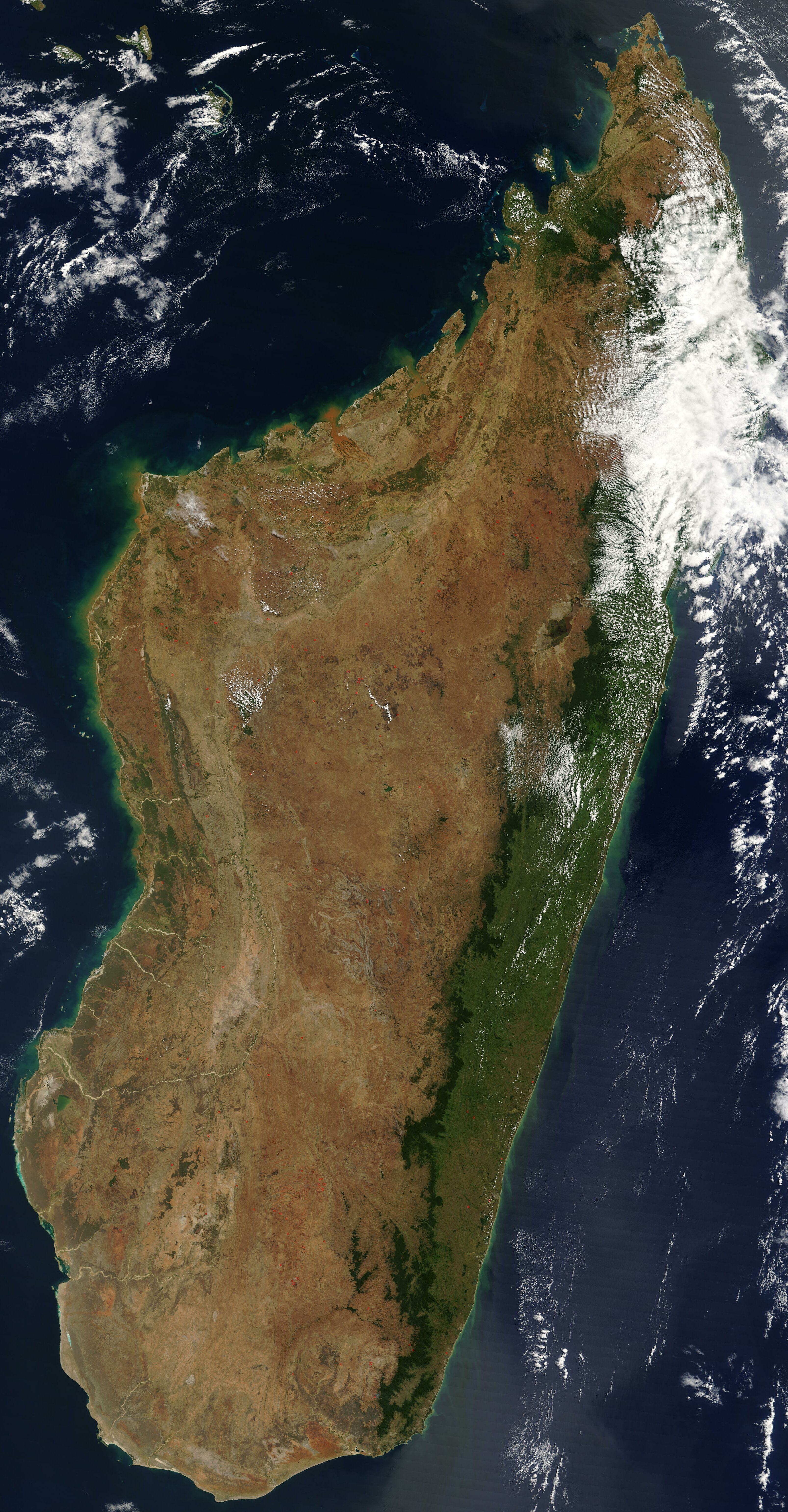
English: Satellite image of Madagascar in September 2003. Slightly cropped, original taken from NASA's Visible Earth: [1]. Original description:
|
| 日付 | |
| 原典 | http://visibleearth.nasa.gov/view_rec.php?id=5769 |
| 作者 | 不明 |
この画像は2005年11月1日の今日の一枚に選ばれました。その際の説明文は以下のとおりでした。 他の言語
Čeština: Pohled ze satelitu na Madagaskar (září 2003) Cymraeg: Delwedd lloeren o Madagascar (Medi 2003) Deutsch: Satellitenbild von Madagaskar English: Satellite image of Madagascar in September Español: Imagen satelital de Madagascar en septiembre Français : Image satellite de Madagascar (septembre 2003) Gaeilge: Radharc Madagascar ó spás. Italiano: Immagine satellitare dell'isola di Madagascar Latina: Madagascariae imago satellitia Nederlands: Sattellietfoto van Madagaskar in september. Norsk bokmål: Satellittbilde av Madagaskar. Norsk nynorsk: Satellittbilde av Madagaskar. Polski: Satelitarny obraz Madagaskaru (wrzesień 2003) Slovenčina: Satelitná snímka Madagaskaru (spetember 2003) Suomi: Syyskuinen Madagaskar satelliittikuvassa Svenska: Satellitbild av Madagaskar. Русский: Спутниковая фотография Мадагаскара, четвёртого по величине острова в мире, сделанная 10 сентября 2003 года. ไทย: ภาพถ่ายดาวเทียมเกาะมาดากัสการ์เมื่อเดือนกันยายน พ.ศ. ๒๕๔๖ 中文: 2003年9月马达加斯加的卫星照片 |
| このファイルはアメリカ航空宇宙局(NASA)によって作成されたものです。NASAの著作権の方針では、特記事項が無い場合、NASAの資料はパブリックドメインとなります。 (詳しくはTemplate:PD-USGov、NASAの著作権の方針について(英語)又はジェット推進研究所(JPL)の画像使用に関するガイドライン(英語)をご覧ください。) |
||
 |
注意事項:
|
ファイルの履歴
過去の版のファイルを表示するには、その版の日時をクリックしてください。
| 日付と時刻 | サムネイル | 寸法 | 利用者 | コメント | |
|---|---|---|---|---|---|
| 現在の版 | 2005年1月7日 (金) 12:51 | | 3,214 × 6,164 (2.94メガバイト) | Hautala | {{PD-USGov-NASA}} Satellite image of Madagascar in September 2003. Slightly cropped, original taken from NASA's Visible Earth http://visibleearth.nasa.gov/cgi-bin/viewrecord?25841 . Original description: The world’s fourth largest island, Madagasca |
ファイルの使用状況
以下のページがこのファイルを使用しています:
グローバルなファイル使用状況
以下に挙げる他のウィキがこの画像を使っています:
- af.wikipedia.org での使用状況
- arz.wikipedia.org での使用状況
- ast.wikipedia.org での使用状況
- az.wikipedia.org での使用状況
- ba.wikipedia.org での使用状況
- be-tarask.wikipedia.org での使用状況
- br.wikipedia.org での使用状況
- ca.wikipedia.org での使用状況
- ce.wikipedia.org での使用状況
- ckb.wikipedia.org での使用状況
- cs.wikipedia.org での使用状況
- cv.wikipedia.org での使用状況
- cy.wikipedia.org での使用状況
- dag.wikipedia.org での使用状況
- da.wikipedia.org での使用状況
- de.wikivoyage.org での使用状況
- diq.wikipedia.org での使用状況
- en.wikipedia.org での使用状況
- eo.wikipedia.org での使用状況
- eo.wiktionary.org での使用状況
- es.wikipedia.org での使用状況
- et.wikipedia.org での使用状況
- fa.wikipedia.org での使用状況
- fi.wikipedia.org での使用状況
- fi.wiktionary.org での使用状況
- fr.wikipedia.org での使用状況
- fr.wikivoyage.org での使用状況
- ga.wikipedia.org での使用状況
- gl.wikipedia.org での使用状況
- gpe.wikipedia.org での使用状況
- ha.wikipedia.org での使用状況
- he.wikipedia.org での使用状況
- ht.wikipedia.org での使用状況
- hy.wikipedia.org での使用状況
- ia.wikipedia.org での使用状況
このファイルのグローバル使用状況を表示する。