
ファイル:Sámova říše.png

このプレビューのサイズ: 601 × 600 ピクセル。 その他の解像度: 241 × 240 ピクセル | 481 × 480 ピクセル | 852 × 850 ピクセル。
元のファイル (852 × 850 ピクセル、ファイルサイズ: 184キロバイト、MIME タイプ: image/png)
ウィキメディア・コモンズのファイルページにある説明を、以下に表示します。
|

|
この地図画像は、ベクターイメージである SVG ファイルとして再作成されるべきです。これにはいくつかの利点があります。詳しくはCommons:Media for cleanupを参照してください。この画像の SVG 形式がすでに利用可能である場合は、アップロードしてください。アップロード後、この画像にあるこのテンプレートを{{Vector version available|新しい画像ファイル名.svg}}テンプレートで置き換えてください。
|
| 解説 |
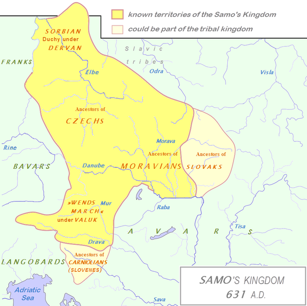
English: Tribal Kingdom of Samo.
Map is based on the maps in:
It is also based on descriptions in:
For eastern and southern extant of tribal kingdom: known territories are shown by the scheme of franco-slavic border and information about the conflicts with Avars is imlemented. The inclusion of Bohemian basin is followed. Contacts with Avars are reached through the territory of Moravians and Eastern Alps. The territories further east and south, which are in proximity of Avars, could be parts of tribal kingdom, too. |
| 日付 | (UTC) |
| 原典 | |
| 作者 |
|
この画像には画像編集が施されています。原本に対して次のデジタル的な変更が行われました。
|
この作品の著作権者である私は、この作品を以下のライセンスで提供します。
| この著作物の著作権者である私は、この著作物における権利を放棄しパブリックドメインとします。これは全世界で適用されます。 一部の国では、これが法的に可能ではない場合があります。その場合は、次のように宣言します。 私は、あらゆる人に対して、法により必要とされている条件を除き、如何なる条件も課すことなく、あらゆる目的のためにこの著作物を使用する権利を与えます。 |
元のアップロードログ
This image is a derivative work of the following images:
- File:Waterways_of_SE_Central_Europe.svg licensed with PD-self
- 2010-01-08T20:49:27Z Kmiki87 1415x1059 (292577 Bytes) {{Information |Description={{en|1=Waterways along the central and lower Danube, including the Bohemian and Carpathian Basins, the northern Balkans, parts of Austria, southern Poland and Western Ukraine.}} |Source={{own}} |Aut
ファイルの履歴
過去の版のファイルを表示するには、その版の日時をクリックしてください。
| 日付と時刻 | サムネイル | 寸法 | 利用者 | コメント | |
|---|---|---|---|---|---|
| 現在の版 | 2013年1月3日 (木) 14:27 | | 852 × 850 (184キロバイト) | DancingPhilosopher | Better map based on http://commons.wikimedia.org/wiki/File:Tribal_Kingdom_of_Samo-sl_version.PNG |
| 2010年10月28日 (木) 14:13 |  | 536 × 474 (616キロバイト) | Aktron | == {{int:filedesc}} == {{OpenStreetMap|name=Sámova říše}} Category:Maps of the history of Austria Category:Maps of the history of Slovakia Category:Maps of the history of Slovenia [[Category:Maps of the history of the Czech Republic |
ファイルの使用状況
以下のページがこのファイルを使用しています:
グローバルなファイル使用状況
以下に挙げる他のウィキがこの画像を使っています:
- ar.wikipedia.org での使用状況
- azb.wikipedia.org での使用状況
- az.wikipedia.org での使用状況
- be.wikipedia.org での使用状況
- bg.wikipedia.org での使用状況
- ca.wikipedia.org での使用状況
- cs.wikipedia.org での使用状況
- de.wikipedia.org での使用状況
- de.wikibooks.org での使用状況
- en.wikipedia.org での使用状況
- et.wikipedia.org での使用状況
- fa.wikipedia.org での使用状況
- fr.wikipedia.org での使用状況
- hy.wikipedia.org での使用状況
- id.wikipedia.org での使用状況
- it.wikipedia.org での使用状況
このファイルのグローバル使用状況を表示する。