
ファイル:RegioniIrredenteItalia.jpg
このプレビューのサイズ: 460 × 600 ピクセル。 その他の解像度: 184 × 240 ピクセル | 632 × 824 ピクセル。
元のファイル (632 × 824 ピクセル、ファイルサイズ: 247キロバイト、MIME タイプ: image/jpeg)
ウィキメディア・コモンズのファイルページにある説明を、以下に表示します。
|
概要
| 解説 |
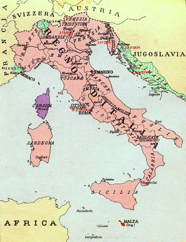
Map of Kingdom of Italy (1919) showing the areas claimed by Irredentism: in red Malta, in purple Corsica, in yellow with green points Dalmatia, Ticino and Nizzardo. I have used as a basic map an old map from an Italian geography and history school book of 1935 "Scuole Medie Inferiori", and I have written and painted on it. Cropped caption: L’Italia dopo la Guerra 1915-1918 |
| 日付 | |
| 原典 | 投稿者自身による著作物 |
| 作者 | Brunodambrosio |
| その他のバージョン | File:Nesvobodni rajoni Italija.png |
ライセンス
| この著作物の著作権者である私は、この著作物における権利を放棄しパブリックドメインとします。これは全世界で適用されます。 一部の国では、これが法的に可能ではない場合があります。その場合は、次のように宣言します。 私は、あらゆる人に対して、法により必要とされている条件を除き、如何なる条件も課すことなく、あらゆる目的のためにこの著作物を使用する権利を与えます。 |
ファイルの履歴
過去の版のファイルを表示するには、その版の日時をクリックしてください。
| 日付と時刻 | サムネイル | 寸法 | 利用者 | コメント | |
|---|---|---|---|---|---|
| 現在の版 | 2023年8月17日 (木) 21:34 | | 632 × 824 (247キロバイト) | 0m9Ep | Color |
| 2017年12月23日 (土) 10:14 |  | 632 × 824 (262キロバイト) | Julieta39 | Blù delle mare | |
| 2012年6月7日 (木) 22:58 |  | 632 × 824 (119キロバイト) | Ras67 | losslessly cropped with Jpegcrop | |
| 2008年4月16日 (水) 22:01 |  | 669 × 903 (144キロバイト) | Brunodambrosio | {{Information |Description=Map of Kingdom of Italy (1919) showing the areas claimed by Irredentism:in red Malta, in purple Corsica, in yellow with green points Dalmatia, Ticino and Nizzardo. I have used as a basic map an old map from an italian geography |
ファイルの使用状況
以下の 2 ページがこのファイルを使用しています:
グローバルなファイル使用状況
以下に挙げる他のウィキがこの画像を使っています:
- als.wikipedia.org での使用状況
- ar.wikipedia.org での使用状況
- ast.wikipedia.org での使用状況
- az.wikipedia.org での使用状況
- be-tarask.wikipedia.org での使用状況
- be.wikipedia.org での使用状況
- ca.wikipedia.org での使用状況
- cs.wikipedia.org での使用状況
- de.wikipedia.org での使用状況
- de.wiktionary.org での使用状況
- en.wikipedia.org での使用状況
- Foreign relations of Italy
- Irredentism
- Italian irredentism
- History of the Kingdom of Italy (1861–1946)
- List of irredentist claims or disputes
- Italian fascism
- Kingdom of Italy
- History of Corsica
- Italian irredentism in Corsica
- Benito Mussolini
- Italian irredentism in Malta
- Italian irredentism in Switzerland
- User:Brothernight/sandbox
- eo.wikipedia.org での使用状況
- es.wikipedia.org での使用状況
- fa.wikipedia.org での使用状況
- fr.wikipedia.org での使用状況
- he.wikipedia.org での使用状況
- hr.wikipedia.org での使用状況
- hu.wikipedia.org での使用状況
- hy.wikipedia.org での使用状況
- id.wikipedia.org での使用状況
このファイルのグローバル使用状況を表示する。