
ファイル:North america terrain 2003.jpg

元のファイル (3,790 × 2,922 ピクセル、ファイルサイズ: 1.9メガバイト、MIME タイプ: image/jpeg)
ウィキメディア・コモンズのファイルページにある説明を、以下に表示します。
|
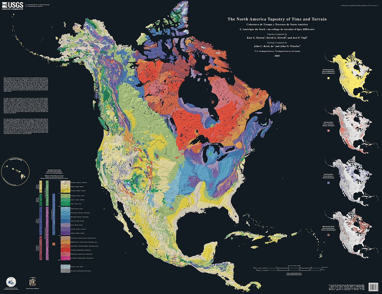
The North America Tapestry of Time and Terrain (1:8,000,000 scale) is a product of the United States Geological Survey in the I-map series (I-2781). This map was prepared in collaboration with the Geological Survey of Canada and the Mexican Consejo Recursos de Minerales.
This cartographic tapestry is woven from a geologic map and a shaded relief image. This digital combination reveals the geologic history of North America through the interrelation of rock type, topography and time. Regional surface processes as well as continent-scale tectonic events are exposed in the three dimensions of space and the fourth dimension, geologic time. The large map shows the varying age of bedrock underlying North America, while four smaller maps show the distribution of four principal types of rock: sedimentary, volcanic, plutonic and metamorphic.
Related images
Four maps show the North American distribution of four principal types of rock: sedimentary, volcanic, plutonic and metamorphic.


There are separate images of the main map, time scale, and rock type maps.
-
 North American terrain
 -
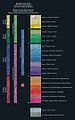 Time scale
 -
 North American rock types


Source
この画像およびメディアは、アメリカ合衆国内務省の実務機関であるアメリカ地質調査所に属する者が職務上作成した著作物のみで構成されているため、アメリカ合衆国国内でパブリックドメインの状態にあります。詳細についてはUSGSの著作物に関する取扱い(英語)をご覧ください。
|
Home: http://pubs.usgs.gov/imap/i2781/
Image: http://pubs.usgs.gov/imap/i2781/i2781_c_low.pdf 144 dpi, encoded to 72 dpi JPEG, compressed slightly to fit within Wikipedia 2MB limit.
Source: English Wikipedia, original upload 15 April 2005 by SEWilco
ファイルの履歴
過去の版のファイルを表示するには、その版の日時をクリックしてください。
| 日付と時刻 | サムネイル | 寸法 | 利用者 | コメント | |
|---|---|---|---|---|---|
| 現在の版 | 2005年9月16日 (金) 16:04 | | 3,790 × 2,922 (1.9メガバイト) | Saperaud~commonswiki | The North America Tapestry of Time and Terrain (1:8,000,000 scale) is a product of the United States Geological Survey in the I-map series (I-2781). This map was prepared in collaboration with the Geological Survey of Canada and the [[Mexican |
ファイルの使用状況
以下のページがこのファイルを使用しています:
グローバルなファイル使用状況
以下に挙げる他のウィキがこの画像を使っています:
- de.wikipedia.org での使用状況
- en.wikipedia.org での使用状況
- en.wikiversity.org での使用状況
- fa.wikipedia.org での使用状況
- www.wikidata.org での使用状況