
ファイル:Nepkoztarsasag.png
高解像度版はありません。
Nepkoztarsasag.png (660 × 428 ピクセル、ファイルサイズ: 55キロバイト、MIME タイプ: image/png)
ウィキメディア・コモンズのファイルページにある説明を、以下に表示します。
|
Accuracy
概要
| 解説 |
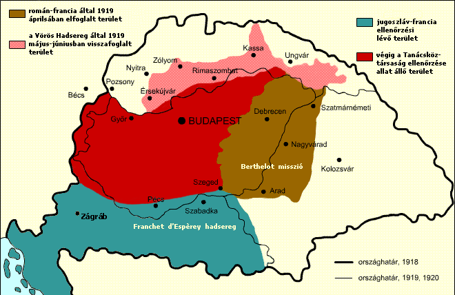
English: Military success of the Hungarian Soviet Republic Territory under Romanian and French control in April, 1919 Territory under the control of the Hungarian Soviet Republic Territory recovered by the Hungarian Soviet Republic Territory under French and Yugoslav control
Italiano: Situazione territoriale della Repubblica sovietica ungherese Territori sotto il controllo rumeno e francese nell'aprile 1919 Territori sotto il controllo della Repubblica sovietica ungherese Territori riconquistati dalla Repubblica sovietica ungherese Territori sotto il controllo francese e jugoslavo
Español: Situación territorial durante el periodo de la República Soviética Húngara Territorio bajo control rumano-francés en abril de 1919. Territorio originalmente bajo control de la República Soviética Húngara Territorio recuperado por la República a Checoslovaquia Territorio bajo control franco-yugoslavo |
| 日付 | |
| 原典 |
hu.wikipedia からコモンズに移動されました。 元のファイルページはこちら。以下の利用者は全てhu.wikipediaに属します。 |
| 作者 | Kovács Ádám |
| その他のバージョン | このファイルの派生的著作物: RepúblicaSoviéticaHúngara1919.svg; Georgian Version SVG |
ライセンス
このファイルはクリエイティブ・コモンズ 表示-継承 2.5 一般ライセンスのもとに利用を許諾されています。
- あなたは以下の条件に従う場合に限り、自由に
- 共有 – 本作品を複製、頒布、展示、実演できます。
- 再構成 – 二次的著作物を作成できます。
- あなたの従うべき条件は以下の通りです。
- 表示 – あなたは適切なクレジットを表示し、ライセンスへのリンクを提供し、変更があったらその旨を示さなければなりません。これらは合理的であればどのような方法で行っても構いませんが、許諾者があなたやあなたの利用行為を支持していると示唆するような方法は除きます。
- 継承 – もしあなたがこの作品をリミックスしたり、改変したり、加工した場合には、あなたはあなたの貢献部分を元の作品とこれと同一または互換性があるライセンスの下に頒布しなければなりません。
ファイルの履歴
過去の版のファイルを表示するには、その版の日時をクリックしてください。
| 日付と時刻 | サムネイル | 寸法 | 利用者 | コメント | |
|---|---|---|---|---|---|
| 現在の版 | 2017年11月22日 (水) 13:15 | | 660 × 428 (55キロバイト) | Julieta39 | Diacritic corrected |
| 2017年11月22日 (水) 12:04 |  | 660 × 428 (55キロバイト) | Julieta39 | According with "Történelmi atlasz", Kartográfiai Vállalat, Budapest 1989, ISBN 9633514223 CM | |
| 2011年2月9日 (水) 11:08 |  | 660 × 428 (47キロバイト) | Hobartimus~commonswiki | Reverted to version as of 18:15, 6 February 2011 | |
| 2011年2月9日 (水) 00:20 |  | 660 × 428 (23キロバイト) | Lovech~commonswiki | returning to the superior original version | |
| 2011年2月6日 (日) 18:15 |  | 660 × 428 (47キロバイト) | 123iti | reverted unexplained edit | |
| 2011年2月5日 (土) 16:40 |  | 660 × 428 (23キロバイト) | Lovech~commonswiki | Reverted to version as of 22:33, 28 December 2010 | |
| 2010年12月29日 (水) 00:17 |  | 660 × 428 (47キロバイト) | 123iti | ok, then I am proposing this compromise version due to my discussion page explanation | |
| 2010年12月28日 (火) 22:33 |  | 660 × 428 (23キロバイト) | VT | Reverted to version as of 13:20, 20 May 2009 -> this version is right, then those territories were under occupation | |
| 2010年12月6日 (月) 11:53 |  | 660 × 428 (35キロバイト) | 123iti | There is no reason that vojvodina is colored here because it had no any relation with Hungarian Soviet Republic. See source: http://libcom.org/files/images/library/hungarianmap%5B1%5D.jpg (Transylvania, Slovakia and Transcarpathia are not colored too, so | |
| 2009年5月20日 (水) 13:20 |  | 660 × 428 (23キロバイト) | Baxter9~commonswiki | {{Information |Description={{en|1=Military succes of the Hungarian Soviet Republic}} |Source=http://hu.wikipedia.org/wiki/F%C3%A1jl:Nepkoztarsasag.png |Author=Kovács Ádám |Date=2006 |Permission= |other_versions= }} <!--{{ImageUpload|full}}--> [[Catego |
ファイルの使用状況
以下の 3 ページがこのファイルを使用しています:
グローバルなファイル使用状況
以下に挙げる他のウィキがこの画像を使っています:
- ar.wikipedia.org での使用状況
- ast.wikipedia.org での使用状況
- azb.wikipedia.org での使用状況
- az.wikipedia.org での使用状況
- be.wikipedia.org での使用状況
- bg.wikipedia.org での使用状況
- cbk-zam.wikipedia.org での使用状況
- cs.wikipedia.org での使用状況
- da.wikipedia.org での使用状況
- el.wikipedia.org での使用状況
- en.wikipedia.org での使用状況
- eo.wikipedia.org での使用状況
- et.wikipedia.org での使用状況
- eu.wikipedia.org での使用状況
- fa.wikipedia.org での使用状況
- fr.wikipedia.org での使用状況
- gl.wikipedia.org での使用状況
- hr.wikipedia.org での使用状況
- hu.wikipedia.org での使用状況
- hy.wikipedia.org での使用状況
- id.wikipedia.org での使用状況
- it.wikipedia.org での使用状況
- ka.wikipedia.org での使用状況
- kk.wikipedia.org での使用状況
- ko.wikipedia.org での使用状況
- la.wikipedia.org での使用状況
- lv.wikipedia.org での使用状況
- mk.wikipedia.org での使用状況
- pl.wikipedia.org での使用状況
このファイルのグローバル使用状況を表示する。