
ファイル:NEAT GBT engl.png

このプレビューのサイズ: 539 × 600 ピクセル。 その他の解像度: 216 × 240 ピクセル | 431 × 480 ピクセル | 852 × 948 ピクセル。
元のファイル (852 × 948 ピクセル、ファイルサイズ: 1.91メガバイト、MIME タイプ: image/png)
ウィキメディア・コモンズのファイルページにある説明を、以下に表示します。
|
概要
| 解説 |
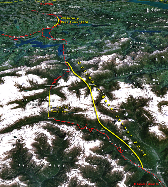
Situation of the northern part of the Gotthard axis as part of the New Railway Link through the Alps NRLA / Alptransit project in Switzerland with Gotthard and Zimmerberg base tunnels |
| 日付 | |
| 原典 | topomap: produced with NASA WorldWind 1.3 / overlay drawing by: Cooper.ch |
| 作者 | --Cooper.ch 19:30, 12 August 2006 (UTC) |
| 許可 (ファイルの再利用) |
NASA satellite imagery is in public domain, and so is my overlay drawing |
| その他のバージョン | Original german version on de.wikipedia.org, named Bild:NEAT_Gotthardachse.png |
ライセンス
| このファイルはアメリカ航空宇宙局(NASA)によって作成されたものです。NASAの著作権の方針では、特記事項が無い場合、NASAの資料はパブリックドメインとなります。 (詳しくはTemplate:PD-USGov、NASAの著作権の方針について(英語)又はジェット推進研究所(JPL)の画像使用に関するガイドライン(英語)をご覧ください。) |
||
 |
注意事項:
|
| 注釈 | この画像には注釈がついています: コモンズで注釈を見る |


ファイルの履歴
過去の版のファイルを表示するには、その版の日時をクリックしてください。
| 日付と時刻 | サムネイル | 寸法 | 利用者 | コメント | |
|---|---|---|---|---|---|
| 現在の版 | 2006年8月12日 (土) 19:30 | | 852 × 948 (1.91メガバイト) | Cooper.ch | {{Information |Description=Situation of the northern axis of the New Railway Link through the Alps NRLA in Switzerland with Gotthard and Zimmerberg base tunnels |Source=topomap: produced with NASA WorldWind 1.3 / drawing overlay by: [[User:Cooper.ch|Coope |
ファイルの使用状況
以下のページがこのファイルを使用しています:
グローバルなファイル使用状況
以下に挙げる他のウィキがこの画像を使っています:
- ast.wikipedia.org での使用状況
- bh.wikipedia.org での使用状況
- da.wikipedia.org での使用状況
- en.wikipedia.org での使用状況
- es.wikipedia.org での使用状況
- fa.wikipedia.org での使用状況
- fi.wikipedia.org での使用状況
- fr.wikipedia.org での使用状況
- he.wikipedia.org での使用状況
- hr.wikipedia.org での使用状況
- jv.wikipedia.org での使用状況
- ml.wikipedia.org での使用状況
- my.wikipedia.org での使用状況
- nl.wikipedia.org での使用状況
- no.wikipedia.org での使用状況
- pt.wikipedia.org での使用状況
- rm.wikipedia.org での使用状況
- ro.wikipedia.org での使用状況
- sh.wikipedia.org での使用状況
- sl.wikipedia.org での使用状況
- sv.wikipedia.org での使用状況
- ta.wikinews.org での使用状況
- tr.wikipedia.org での使用状況
- zh.wikipedia.org での使用状況