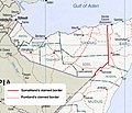
ファイル:Map of somaliland border claims.jpg
Map_of_somaliland_border_claims.jpg (590 × 504 ピクセル、ファイルサイズ: 118キロバイト、MIME タイプ: image/jpeg)
ファイルの履歴
過去の版のファイルを表示するには、その版の日時をクリックしてください。
| 日付と時刻 | サムネイル | 寸法 | 利用者 | コメント | |
|---|---|---|---|---|---|
| 現在の版 | 2023年10月19日 (木) 17:16 |  | 590 × 504 (118キロバイト) | Maantadhabtiye | https://horseedmedia.net/somali-federal-government-recognizes-new-ssc-khatumo-administration-383891 |
| 2020年6月20日 (土) 18:37 |  | 590 × 504 (241キロバイト) | Kzl55 | Reverted to version as of 12:41, 23 November 2018 (UTC) Map based on Markus Hoehne's work Between Somaliland and Puntland (Contested Borderlands), 2015. | |
| 2020年6月17日 (水) 15:55 |  | 590 × 504 (115キロバイト) | Meelpringthusss | Puntland's proclaimed borders per official government release - http://mediapuntland.org/puntland-map-calls-for-peace-and-respect-for-sacredness-of-human-life-amid-tensions-in-sool-region/ | |
| 2018年11月23日 (金) 12:41 |  | 590 × 504 (241キロバイト) | Kzl55 | Updated based on Markus Hoehne's map in Between Somaliland and Puntland (Contested Borderlands), 2015. | |
| 2007年10月19日 (金) 19:49 |  | 506 × 586 (167キロバイト) | Béka~commonswiki | {{Information |Description=Map of Somaliland border dispute as of August, 2007. Modification of Image:Somalia pol02.jpg fro Wikimedia Commons. en:Category:Maps of Somalia en:Category:PD tag needs updating |Source=Originally from [http://en.wi |
ファイルの使用状況
以下のページがこのファイルを使用しています:
グローバルなファイル使用状況
以下に挙げる他のウィキがこの画像を使っています:
- ast.wikipedia.org での使用状況
- cs.wikipedia.org での使用状況
- en.wikibooks.org での使用状況
- eo.wikipedia.org での使用状況
- es.wikipedia.org での使用状況
- fr.wikipedia.org での使用状況
- gl.wikipedia.org での使用状況
- it.wikipedia.org での使用状況
- ml.wikipedia.org での使用状況
- pt.wikipedia.org での使用状況
- ru.wikipedia.org での使用状況
- uk.wikipedia.org での使用状況
- zh.wikipedia.org での使用状況


