
ファイル:Map of Russia - Far Eastern Federal District (2018 composition).svg

この SVG ファイルのこの PNG プレビューのサイズ: 800 × 462 ピクセル. その他の解像度: 320 × 185 ピクセル | 640 × 369 ピクセル | 1,024 × 591 ピクセル | 1,280 × 738 ピクセル | 2,560 × 1,477 ピクセル | 1,092 × 630 ピクセル。
元のファイル (SVG ファイル、1,092 × 630 ピクセル、ファイルサイズ: 61キロバイト)
ウィキメディア・コモンズのファイルページにある説明を、以下に表示します。
|
.svg?uselang=ja)
.svg?uselang=ja)
.svg?uselang=ja&action=history)
.svg)

|
The boundaries on this map show the de facto situation. This is just one of several different views on the subject (see COM:NPOV). |
概要
| 解説 |
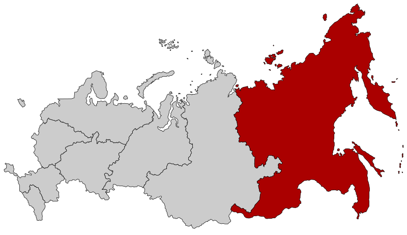
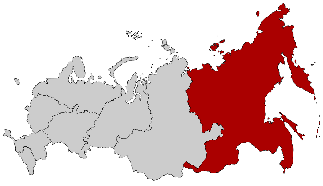
English: Map Russia highlighting the Far Eastern Federal district as of 2018-11-03. Español: Ubicación del Distrito Federal de Lejano Oriente en la Federación Rusa Русский: Дальневосточный федеральный округ |
| 日付 | (UTC) |
| 原典 |
このファイルの派生元: |
| 作者 |
この画像には画像編集が施されています。原本に対して次のデジタル的な変更が行われました。
|
ライセンス
このファイルはクリエイティブ・コモンズ 表示-継承 2.5 一般ライセンスのもとに利用を許諾されています。
- あなたは以下の条件に従う場合に限り、自由に
- 共有 – 本作品を複製、頒布、展示、実演できます。
- 再構成 – 二次的著作物を作成できます。
- あなたの従うべき条件は以下の通りです。
- 表示 – あなたは適切なクレジットを表示し、ライセンスへのリンクを提供し、変更があったらその旨を示さなければなりません。これらは合理的であればどのような方法で行っても構いませんが、許諾者があなたやあなたの利用行為を支持していると示唆するような方法は除きます。
- 継承 – もしあなたがこの作品をリミックスしたり、改変したり、加工した場合には、あなたはあなたの貢献部分を元の作品とこれと同一または互換性があるライセンスの下に頒布しなければなりません。
元のアップロードログ
This image is a derivative work of the following images:
- File:Map of Russia - Far Eastern Federal District.svg licensed with Cc-by-sa-2.5
- 2018-11-04T19:12:00Z Seryo93 1092x630 (97483 Bytes) Reverted to version as of 14:21, 10 March 2015 (UTC): will upload separately
- 2018-11-04T19:11:17Z Seryo93 1092x630 (62312 Bytes) cleanup
- 2018-11-04T19:04:20Z Seryo93 1092x630 (287327 Bytes) Update from [[:File:Map_of_Russian_districts,_2018-11-04.svg]]
- 2015-03-10T14:21:00Z Knyaz-1988 1092x630 (97483 Bytes) Reverted to version as of 22:12, 3 November 2014
- 2014-11-04T01:32:51Z Fry1989 1092x630 (120531 Bytes) NPOV issue.
- 2014-11-03T22:12:44Z Knyaz-1988 1092x630 (97483 Bytes) New version
- 2010-01-22T20:29:49Z Denhud 1092x630 (120531 Bytes) On 2010-01-19 Southern Federal District split in two, with its former southern territories forming new North Caucasian Federal District.
- 2010-01-21T22:25:25Z Denhud 1092x630 (120531 Bytes) On 2010-01-19 Southern Federal District split in two, with its former southern territories forming new North Caucasian Federal District.
- 2008-03-03T23:36:42Z Lokal Profil 1092x630 (114976 Bytes) {{Information |Description=Map Russia highlighting the Far Eastern [[:en:Federal districts of Russia|Federal districts]]. |Source=Based on [[:Image:Map of Russian subjects, 2008-03-01.svg|Map of Russian subjects, 2008-03-01.s
- File:Map of Russian districts, 2018-11-04.svg licensed with Cc-by-sa-2.5
Uploaded with derivativeFX
ファイルの履歴
過去の版のファイルを表示するには、その版の日時をクリックしてください。
| 日付と時刻 | サムネイル | 寸法 | 利用者 | コメント | |
|---|---|---|---|---|---|
| 現在の版 | 2018年11月4日 (日) 19:15 | | 1,092 × 630 (61キロバイト) | Seryo93 | == {{int:filedesc}} == {{Information |Description={{en|Map Russia highlighting the '''Far Eastern Federal district''' as of 2018-11-03.}} {{es|Ubicación del Distrito Federal de Lejano Oriente en la Federación Rusa}} {{Ru|Дальневосточный федеральный округ}} |Source={{Derived from|Map of Russia - Far Eastern Federal District.svg|Map of Russian districts, 2018-11-04.svg|display=50}} |Date=2018-11-04 19:14 (UTC) |Author=* [[:File:Map of Russia - Far Eastern Fed... |
ファイルの使用状況
以下のページがこのファイルを使用しています:
グローバルなファイル使用状況
以下に挙げる他のウィキがこの画像を使っています:
- ar.wikipedia.org での使用状況
- ast.wikipedia.org での使用状況
- az.wikipedia.org での使用状況
- be-tarask.wikipedia.org での使用状況
- ca.wikipedia.org での使用状況
- cs.wikipedia.org での使用状況
- cv.wikipedia.org での使用状況
- el.wikipedia.org での使用状況
- en.wikipedia.org での使用状況
- Russian Far East
- Far Eastern Federal District
- Category:Russian Far East
- User:Paukrus
- User:Paukrus/Userbox
- User:Paukrus/Userbox/Russian Far East
- User:Profwill
- User:Glucke
- Category:Geography of the Russian Far East
- Category:Landforms of the Russian Far East
- User:Antanaklasis
- Category:Far Eastern Federal District
- User:Weneedwikipedia
- Wikipedia:Userboxes/Location/Russia
- User:Dikivan2000
- en.wikinews.org での使用状況
- eo.wikipedia.org での使用状況
- et.wikipedia.org での使用状況
- fi.wikipedia.org での使用状況
このファイルのグローバル使用状況を表示する。
.svg)
.svg)