
ファイル:Map of Iceland.svg

この SVG ファイルのこの PNG プレビューのサイズ: 739 × 600 ピクセル. その他の解像度: 296 × 240 ピクセル | 591 × 480 ピクセル | 946 × 768 ピクセル | 1,261 × 1,024 ピクセル | 2,523 × 2,048 ピクセル | 1,834 × 1,489 ピクセル。
元のファイル (SVG ファイル、1,834 × 1,489 ピクセル、ファイルサイズ: 717キロバイト)
ウィキメディア・コモンズのファイルページにある説明を、以下に表示します。
|
概要
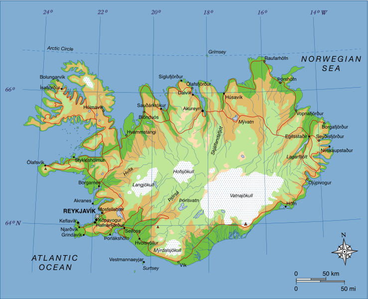
| 解説 | A map of Iceland, showing major towns, rivers, lakes and glaciers. Translated from a map on the Greek Wikipedia (located here). |
| 日付 | |
| 原典 | 投稿者自身による著作物, based on File:Map of Iceland el.svg created by el:user:Αντιγόνη |
| 作者 | Max Naylor |
ライセンス
| この著作物は、著作者であるI, Max Naylorによって権利が放棄され、パブリックドメインとされました。これは全世界で適用されます。 一部の国では、これが法的に可能ではない場合があります。その場合は、次のように宣言します。 I, Max Naylorは、あらゆる人に対して、法により必要とされている条件を除き、如何なる条件も課すことなく、あらゆる目的のためにこの著作物を使用する権利を与えます。 |
| 注釈 | この画像には注釈がついています: コモンズで注釈を見る |
ファイルの履歴
過去の版のファイルを表示するには、その版の日時をクリックしてください。
| 日付と時刻 | サムネイル | 寸法 | 利用者 | コメント | |
|---|---|---|---|---|---|
| 現在の版 | 2007年6月23日 (土) 19:15 | | 1,834 × 1,489 (717キロバイト) | Max Naylor~commonswiki | == Summary == {{Information |Description=A map of Iceland, showing major towns, rivers, lakes and glaciers. Translated from a map on the Greek Wikipedia ([http://el.wikipedia.org/wiki/Εικόνα:Map_of_Iceland.svg located here]). |Source=self-made |Date |
| 2007年6月23日 (土) 19:11 |  | 1,834 × 1,489 (710キロバイト) | Max Naylor~commonswiki | == Summary == {{Information |Description=A map of Iceland, showing major towns, rivers, lakes and glaciers. Translated from a map on the Greek Wikipedia ([http://el.wikipedia.org/wiki/Εικόνα:Map_of_Iceland.svg located here]). |Source=self-made |Date | |
| 2007年6月23日 (土) 19:07 |  | 1,834 × 1,489 (694キロバイト) | Max Naylor~commonswiki | {{Information |Description=A map of Iceland, showing major towns, rivers, lakes and glaciers. Translated from a map on the Greek Wikipedia ([http://el.wikipedia.org/wiki/Εικόνα:Map_of_Iceland.svg located here]). |Source=self-made |Date=23 June 2007 |
ファイルの使用状況
グローバルなファイル使用状況
以下に挙げる他のウィキがこの画像を使っています:
- af.wikipedia.org での使用状況
- ar.wikipedia.org での使用状況
- arz.wikipedia.org での使用状況
- avk.wikipedia.org での使用状況
- azb.wikipedia.org での使用状況
- bg.wikipedia.org での使用状況
- bn.wikipedia.org での使用状況
- co.wikipedia.org での使用状況
- cs.wikipedia.org での使用状況
- da.wikipedia.org での使用状況
- de.wikipedia.org での使用状況
- de.wikibooks.org での使用状況
- dz.wikipedia.org での使用状況
- el.wikipedia.org での使用状況
- en.wikipedia.org での使用状況
- en.wikibooks.org での使用状況
- en.wikiquote.org での使用状況
- fa.wikipedia.org での使用状況
- fi.wikipedia.org での使用状況
- fo.wikipedia.org での使用状況
- fr.wikipedia.org での使用状況
- gag.wikipedia.org での使用状況
- gv.wikipedia.org での使用状況
- he.wikipedia.org での使用状況
このファイルのグローバル使用状況を表示する。