
ファイル:Map of Eagle County, Colorado.png
元のファイル (3,265 × 2,571 ピクセル、ファイルサイズ: 56キロバイト、MIME タイプ: image/png)
ウィキメディア・コモンズのファイルページにある説明を、以下に表示します。
|
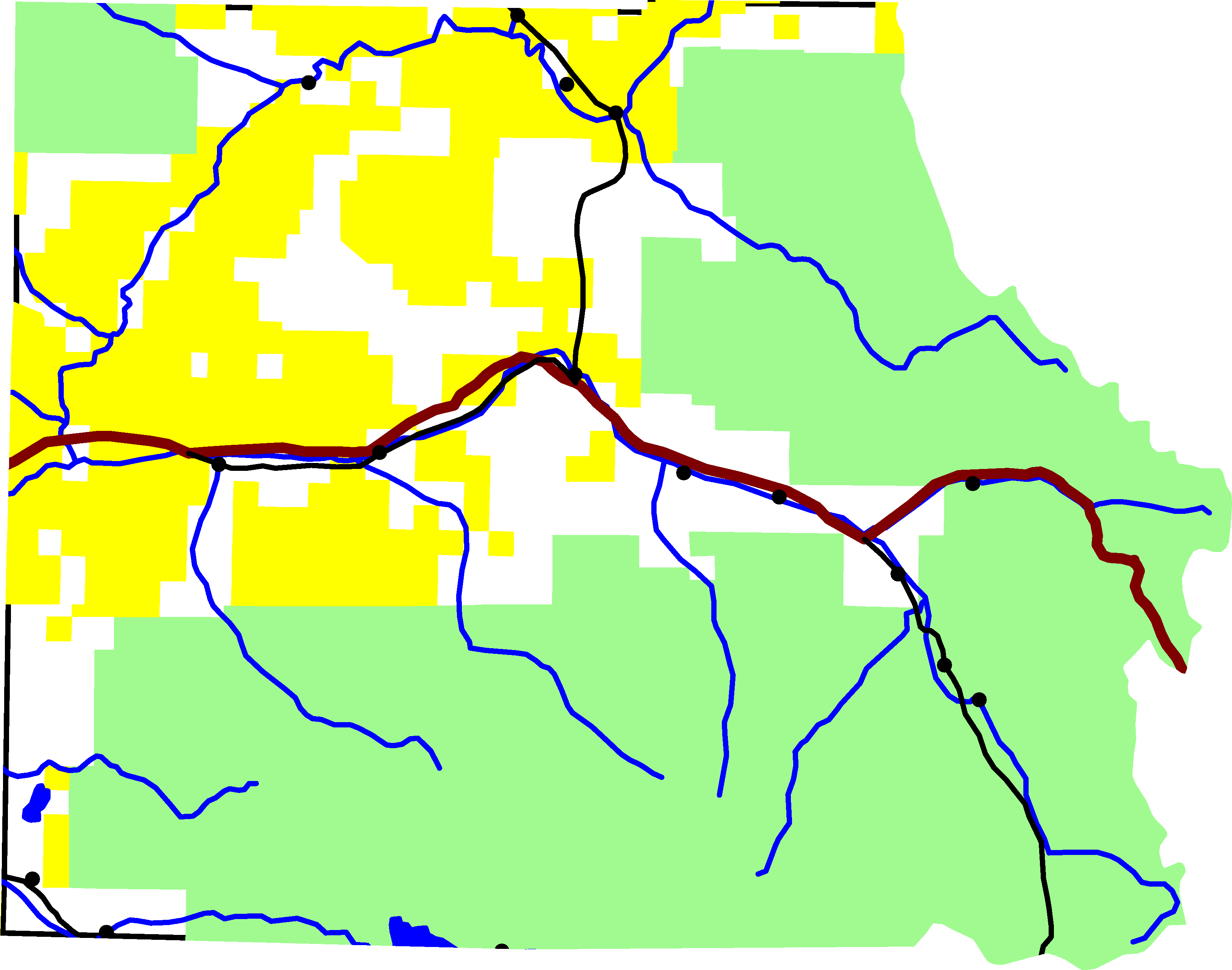
A map of Eagle County, Colorado. Green is White River National Forest, yellow is Bureau of Land Management land. The reddish line from east to west is Interstate 70. The black lines are roads. In the southeastern quadrant is U.S. Highway 24. In the north-central is Colorado State Highway 131. Running along I-70 is U.S. Highway 6. And in the south-west corner is Colorado State Highway 82.
For scale, the county is about 50 miles wide.
The lake on the southern border is Ruedi Reservior, with Fryingpan River. Gore Creek is the easternmost river on the map. It joins the Eagle River, which starts in the south-east corner of the county and flows north-west until it joins I-70. The river in the northern half of the county is the Colorado River.
David Benbennick made this map from data at nationalatlas.gov. The data is accurate to 0.000278 degrees, or about 65 feet.
| この著作物の著作権者である私は、この著作物における権利を放棄しパブリックドメインとします。これは全世界で適用されます。 一部の国では、これが法的に可能ではない場合があります。その場合は、次のように宣言します。 私は、あらゆる人に対して、法により必要とされている条件を除き、如何なる条件も課すことなく、あらゆる目的のためにこの著作物を使用する権利を与えます。 |
ファイルの履歴
過去の版のファイルを表示するには、その版の日時をクリックしてください。
| 日付と時刻 | サムネイル | 寸法 | 利用者 | コメント | |
|---|---|---|---|---|---|
| 現在の版 | 2005年8月6日 (土) 22:23 | | 3,265 × 2,571 (56キロバイト) | Dbenbenn | lighter green for national forest, #A0F090, taken from w:Wikipedia talk:WikiProject Maps |
| 2005年8月2日 (火) 16:01 |  | 3,265 × 2,571 (56キロバイト) | Dbenbenn | put county boundary underneath everything else. More accurate display at border. | |
| 2005年8月1日 (月) 16:15 |  | 3,265 × 2,571 (58キロバイト) | Dbenbenn | by me, PD |
ファイルの使用状況
以下のページがこのファイルを使用しています:
グローバルなファイル使用状況
以下に挙げる他のウィキがこの画像を使っています:
- en.wikipedia.org での使用状況
- es.wikipedia.org での使用状況
- ro.wikipedia.org での使用状況