
ファイル:Map indicating Prince Regent Inlet, Nunavut, Canada.png
高解像度版はありません。
Map_indicating_Prince_Regent_Inlet,_Nunavut,_Canada.png (385 × 330 ピクセル、ファイルサイズ: 56キロバイト、MIME タイプ: image/png)
ウィキメディア・コモンズのファイルページにある説明を、以下に表示します。
|
概要
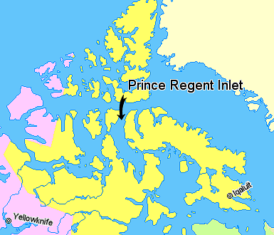
Map indicating Prince Regent Inlet, Nunavut, Canada.
Nunavut
Northwest Territories
Greenland
© Her Majesty the Queen in Right of Canada, Department of Natural Resources. All rights reserved.
Licence Agreement
ライセンス

|
この作品の著作権者は、あらゆる人に対し、無制約の再配布、商用利用及び改変を含むあらゆる目的でこの作品を利用することを認めます。
注意
|
ファイルの履歴
過去の版のファイルを表示するには、その版の日時をクリックしてください。
| 日付と時刻 | サムネイル | 寸法 | 利用者 | コメント | |
|---|---|---|---|---|---|
| 現在の版 | 2006年3月22日 (水) 02:31 | | 385 × 330 (56キロバイト) | David Kernow~commonswiki | == Summary == Map indicating Prince Regent Inlet, Nunavut, Canada. {{legend|#ffff66|Nunavut}} {{legend|#ffccff|Northwest Territories}} {{legend|#ffffcc|Greenland}} <br> © Her Majesty the Queen in Right of Canada, Department |
ファイルの使用状況
以下のページがこのファイルを使用しています:
グローバルなファイル使用状況
以下に挙げる他のウィキがこの画像を使っています:
- az.wikipedia.org での使用状況
- bg.wikipedia.org での使用状況
- de.wikipedia.org での使用状況
- en.wikipedia.org での使用状況
- es.wikipedia.org での使用状況
- fr.wikipedia.org での使用状況
- nl.wikipedia.org での使用状況
- pl.wikipedia.org での使用状況
- pt.wikipedia.org での使用状況
- zh.wikipedia.org での使用状況