
ファイル:LuxembourgPartitionsMap english.jpg
高解像度版はありません。
LuxembourgPartitionsMap_english.jpg (433 × 569 ピクセル、ファイルサイズ: 46キロバイト、MIME タイプ: image/jpeg)
ウィキメディア・コモンズのファイルページにある説明を、以下に表示します。
|

|
このファイルは、File:LuxembourgPartitionsMap english.pngによって代替されています。このファイルの代わりに、他のファイルを使うことをお薦めします。代替されたファイルの削除には合意が必要なことに注意してください。
|

|
概要
| 解説 |
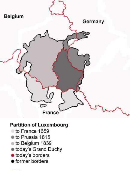
English: Map showing the partition of Luxembourg through the centuries.
Français : Carte montrant la partition du Luxembourg à travers les siècles, avec explications an anglais. |
| 日付 | |
| 原典 |
|
| 作者 | Spanish_Inquisition |
| その他のバージョン |
|


ライセンス
| この著作物の著作権者である私は、この著作物における権利を放棄しパブリックドメインとします。これは全世界で適用されます。 一部の国では、これが法的に可能ではない場合があります。その場合は、次のように宣言します。 私は、あらゆる人に対して、法により必要とされている条件を除き、如何なる条件も課すことなく、あらゆる目的のためにこの著作物を使用する権利を与えます。 |
ファイルの履歴
過去の版のファイルを表示するには、その版の日時をクリックしてください。
| 日付と時刻 | サムネイル | 寸法 | 利用者 | コメント | |
|---|---|---|---|---|---|
| 現在の版 | 2008年7月21日 (月) 18:11 | | 433 × 569 (46キロバイト) | Pretty Green~commonswiki | {{Information |Description= As previous, with rivers removed from map for clarity |Source= previous version |Date= 21 July 2008 |Author= Spanish Inquisition, modified by Pretty Green |Permission= |other_versions= }} |
| 2006年9月3日 (日) 14:58 |  | 433 × 569 (82キロバイト) | Spanish Inquisition | Map showing the partition of Luxembourg thorugh the centuries with english expanantions. Modification of the image LuxembourgPartitionsMap.png by user:QuartierLatin1968 14:10, 22 Apr 2005 (UTC). Author: user:Spanish_Inquisition Date: 3rd September 2006 |
ファイルの使用状況
以下のページがこのファイルを使用しています:
グローバルなファイル使用状況
以下に挙げる他のウィキがこの画像を使っています:
- bg.wikipedia.org での使用状況
- en.wikipedia.org での使用状況
- he.wikipedia.org での使用状況
- it.wikipedia.org での使用状況
- mn.wikipedia.org での使用状況
- no.wikipedia.org での使用状況
- th.wikipedia.org での使用状況
- vi.wikipedia.org での使用状況