
ファイル:Lockheed 8 Sirius 'Tingmissartoq' at the National Air and Space Museum, Washington DC.jpg

元のファイル (1,600 × 1,066 ピクセル、ファイルサイズ: 503キロバイト、MIME タイプ: image/jpeg)
ウィキメディア・コモンズのファイルページにある説明を、以下に表示します。
|
| 解説 |
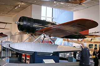
Every possible space in the aircraft was utilized, including the wings and floats, which contained the gasoline tanks. There was plenty of emergency equipment in case the Lindberghs had to make a forced landing in the frozen wilderness. From New York, the Lindberghs flew up the eastern border of Canada to Hopedale, Labrador. From Hopedale they made the first major overwater hop, 650 miles to Godthaab, Greenland, where the Sirius acquired its name—Tingmissartoq, which in Eskimo means "one who flies like a big bird." After crisscrossing Greenland to Baffin Island and back, and then on to Iceland, the Lindberghs proceeded to the major cities of Europe and as far east as Moscow, down the west coast of Africa, and across the South Atlantic to South America. where they flew down the Amazon, and then north through Trinidad and Barbados and back to the United States. They returned to New York on December 19, having traveled 30,000 miles to four continents and twenty-one countries. The information gained from the trip proved invaluable in planning commercial air transport routes for the North and South Atlantic. The aircraft was in the American Museum of Natural History in New York City until 1955. The AirForce Museum in Dayton, Ohio, then acquired it and transferred it to the Smithsonian in 1959. collections.nasm.si.edu/code/emuseum.asp?profile=objects&... |
| 日付 | |
| 原典 | Lockheed 8 Sirius "Tingmissartoq" |
| 作者 | Cliff from I now live in Arlington, VA (Outside Washington DC), USA |
| カメラの位置 | | 以下のサービスでこの位置を確認する: オープンストリートマップ |
|---|
ライセンス
- あなたは以下の条件に従う場合に限り、自由に
- 共有 – 本作品を複製、頒布、展示、実演できます。
- 再構成 – 二次的著作物を作成できます。
- あなたの従うべき条件は以下の通りです。
- 表示 – あなたは適切なクレジットを表示し、ライセンスへのリンクを提供し、変更があったらその旨を示さなければなりません。これらは合理的であればどのような方法で行っても構いませんが、許諾者があなたやあなたの利用行為を支持していると示唆するような方法は除きます。
| この画像は当初、cliff1066™ によって Flickr の https://www.flickr.com/photos/28567825@N03/3344241041 に投稿されたものです。2009-11-15、FlickreviewR ボットによってレビューされ、cc-by-2.0 のライセンスで提供されていることが確認されました。 |
ファイルの履歴
過去の版のファイルを表示するには、その版の日時をクリックしてください。
| 日付と時刻 | サムネイル | 寸法 | 利用者 | コメント | |
|---|---|---|---|---|---|
| 現在の版 | 2009年11月15日 (日) 18:01 | | 1,600 × 1,066 (503キロバイト) | Geo Swan | {{Information |Description=Every possible space in the aircraft was utilized, including the wings and floats, which contained the gasoline tanks. There was plenty of emergency equipment in case the Lindberghs had to make a forced landing in the frozen wil |
ファイルの使用状況
以下のページがこのファイルを使用しています:
グローバルなファイル使用状況
以下に挙げる他のウィキがこの画像を使っています:
- ar.wikipedia.org での使用状況
- ast.wikipedia.org での使用状況
- ca.wikipedia.org での使用状況
- en.wikipedia.org での使用状況
- es.wikipedia.org での使用状況
- fa.wikipedia.org での使用状況
- fr.wikipedia.org での使用状況
- gl.wikipedia.org での使用状況
- id.wikipedia.org での使用状況
- no.wikipedia.org での使用状況
- pt.wikipedia.org での使用状況
- vi.wikipedia.org での使用状況
- www.wikidata.org での使用状況