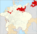
ファイル:Locator Brandenburg-Prussia within the Holy Roman Empire (1618).svg

この SVG ファイルのこの PNG プレビューのサイズ: 658 × 600 ピクセル. その他の解像度: 263 × 240 ピクセル | 527 × 480 ピクセル | 843 × 768 ピクセル | 1,123 × 1,024 ピクセル | 2,247 × 2,048 ピクセル | 2,769 × 2,524 ピクセル。
元のファイル (SVG ファイル、2,769 × 2,524 ピクセル、ファイルサイズ: 1,024キロバイト)
ファイルの履歴
過去の版のファイルを表示するには、その版の日時をクリックしてください。
| 日付と時刻 | サムネイル | 寸法 | 利用者 | コメント | |
|---|---|---|---|---|---|
| 現在の版 | 2015年1月28日 (水) 00:50 |  | 2,769 × 2,524 (1,024キロバイト) | Sir Iain | Corrected Bohemian border |
| 2015年1月27日 (火) 14:20 |  | 2,769 × 2,524 (1,014キロバイト) | Sir Iain | Redone Schleswig-Holstein | |
| 2015年1月5日 (月) 00:55 |  | 2,769 × 2,524 (994キロバイト) | Sir Iain | Savoy shown as core territory of the HRR | |
| 2014年12月23日 (火) 20:28 |  | 2,769 × 2,524 (994キロバイト) | Sir Iain | Removed the Imperial border between Germany and the Netherlands | |
| 2014年12月22日 (月) 14:56 |  | 2,769 × 2,524 (999キロバイト) | Sir Iain | User created page with UploadWizard |
ファイルの使用状況
以下の 2 ページがこのファイルを使用しています:
グローバルなファイル使用状況
以下に挙げる他のウィキがこの画像を使っています:
- azb.wikipedia.org での使用状況
- bg.wikipedia.org での使用状況
- bxr.wikipedia.org での使用状況
- cs.wikipedia.org での使用状況
- de.wikipedia.org での使用状況
- en.wikipedia.org での使用状況
- en.wikibooks.org での使用状況
- eo.wikipedia.org での使用状況
- es.wikipedia.org での使用状況
- fi.wikipedia.org での使用状況
- fr.wikipedia.org での使用状況
- he.wikipedia.org での使用状況
- id.wikipedia.org での使用状況
- it.wikipedia.org での使用状況
- ko.wikipedia.org での使用状況
- lv.wikipedia.org での使用状況
- pl.wikipedia.org での使用状況
- ru.wikipedia.org での使用状況
- ru.wikiversity.org での使用状況
- th.wikipedia.org での使用状況
- tr.wikipedia.org での使用状況
- ur.wikipedia.org での使用状況
- vi.wikipedia.org での使用状況
- vls.wikipedia.org での使用状況
- zh.wikipedia.org での使用状況
