
ファイル:Extent of the Hansa.png

このプレビューのサイズ: 800 × 445 ピクセル。 その他の解像度: 320 × 178 ピクセル | 640 × 356 ピクセル | 1,250 × 695 ピクセル。
元のファイル (1,250 × 695 ピクセル、ファイルサイズ: 141キロバイト、MIME タイプ: image/png)
ウィキメディア・コモンズのファイルページにある説明を、以下に表示します。
|
| 解説 |
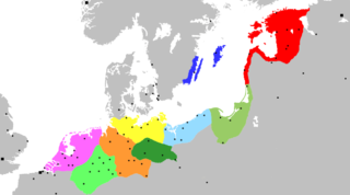
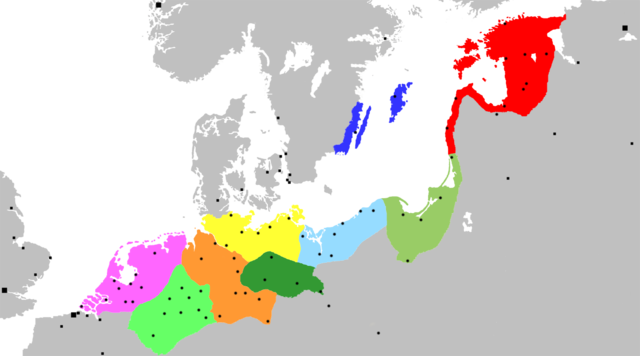
Map of the Hanseatic League, circa 1400, showing Circles, Kontore and principal Hanseatic cities Netherlands Circle
Westphalian Circle
Saxon Circle
Wendish Circle
Margravian Circle
Pomeranian Circle
Prussian Circle
Livonian Circle
Swedish Circle
Squares indicate Kontore; dots indicate Hanseatic cities. |
||
| 日付 | (UTC) | ||
| 原典 | Adapted from Image:Extent of the Hansa.jpg, itself in the public domain because its first publication occurred in 1902 — prior to January 1, 1923 | ||
| 作者 | OwenBlacker | ||
| 許可 (ファイルの再利用) |
|
||
| その他のバージョン | Image:Extent of the Hansa.jpg |
ファイルの履歴
過去の版のファイルを表示するには、その版の日時をクリックしてください。
| 日付と時刻 | サムネイル | 寸法 | 利用者 | コメント | |
|---|---|---|---|---|---|
| 現在の版 | 2007年11月20日 (火) 00:12 | | 1,250 × 695 (141キロバイト) | OwenBlacker | {{Information |Description= Map of the Hanseatic League, circa 1400, showing Circles, ''Kontore'' and principal Hanseatic cities |Source= Adapted from Image:Extent of the Hansa.jpg |Date=~~~~~ |Author=~~~ |Permission={{PD-self}} |other_versio |
ファイルの使用状況
以下のページがこのファイルを使用しています:
グローバルなファイル使用状況
以下に挙げる他のウィキがこの画像を使っています:
- af.wikipedia.org での使用状況
- ar.wikipedia.org での使用状況
- برلين
- تالين
- هامبورغ
- ستوكهولم
- ريغا
- لندن
- براونشفايغ (مدينة)
- كولونيا
- بريمن
- ماغديبورغ
- الرابطة الهانزية
- نيوكاسل أبون تاين
- إبسوتش
- روستوك
- بوخوم
- دورتموند
- مونستر
- دويسبورغ
- شتاده
- لونبورغ
- ستارغارد
- كيل
- كراكوف
- فروتسواف
- برغن
- لوبيك
- كالينينغراد
- بيتيرهوف
- بسكوف
- فيليكي نوفغورود
- إرفورت
- كينغستون أبون هال
- أنتويرب
- بروج
- يورك
- كاوناس
- تارتو
- بوسطن (إنجلترا)
- أوسنابروك
- تورون
- هام (مدينة)
- غدانسك
- مولهاوزن (تورينغيا)
- هاله (سكسونيا-أنهالت)
- قالب:الرابطة الهانزية
- فيسبي
- هاردرفايك
- كونيغسبرغ
- خرننغن
このファイルのグローバル使用状況を表示する。