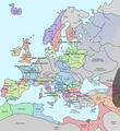
ファイル:Europe in 1345.png

ページのコンテンツが他言語でサポートされていません。

元のファイル(1,075 × 1,168 ピクセル、ファイルサイズ: 114キロバイト、MIME タイプ: image/png)

概要

解説 A map of Europe in 1345, showing the location of events that took place in that year. The Black Plague's exact location in unknown, and the shaded area to the right represents rough scholarly estimates. It hit the Crimea in the following year.
日付
原典 self-made from Image:Europein1328.png with GIMP
作者 Teaandcrumpets
このhistorical map画像は、ベクターイメージである SVG ファイルとして再作成されるべきです。これにはいくつかの利点があります。詳しくはCommons:Media for cleanupを参照してください。この画像の SVG 形式がすでに利用可能である場合は、アップロードしてください。アップロード後、この画像にあるこのテンプレートを{{Vector version available|新しい画像ファイル名.svg}}テンプレートで置き換えてください。
Maps of the history of Europe
BCE
aC

Weichselian ice age (c. 113,000–9700) · Neolithic expansion (c. 7000–4500) · Middle Neolithic (c. 4500–4000) · Late Neolithic (c. 4000–3000) · Copper Age – Corded Ware culture (c. 2900–2350) · Copper Age – Bellbeaker culture (c. 2800–1800) · Early Bronze Age – Unetice culture (c. 2300–1600) · Late Bronze Age – Urnfield culture (c. 1300—750) · Migrations (c. 1000–100) · Hallstatt & La Tène cultures (c. 800–100) · Roman Republic (510–40) · 220 · 218 · 200 · 201–100 · 58 · 49 · 39 · 30 BCE–6 CE


CE
dC

14 · 14–37 · 60 · 60 · 69 · 80 · Migrations 100–500 · 117 · 117 · 125 · Migrations 150–774 · Economy 180 · 271 · 293–305 · 337 · 395 · c. 395 · 400 · 400 · 450 · 457–61 · 476 · 480 · Franks 481–814 · Early Slavs 500–700 · 500 · 526 · 526–600 · Christianisation to 600 · c. 550 · 650 · Pontic Steppe 650 · 665 · 800 · Vikings 800–1050 · 814 · 843–70 · 850 · 900 · 912 · 998 · 1000 · 1000 · 1054 · 1092 · First Crusade 1095–99 · 1097 · 1135 · 1142 · 1147–49 · 1190 · 1190 · 1250 · c. 1250 · 1301-1400 · 1301-1400 · 1328 · 1345 · Black Plague 1347–51 · 1360 · 1400 · Trade routes c. 1400 · 1430 · 1470 · 1490 · 1492 · 1500 · 1519 · 1550 · 1560 · Religion 1560 · Religion 1600 · Religion 1618 · 1618–48 · 1648 · 1683 · 1700 · 1701 · 1708 · 1714 · 1721 · 1725–30 · 1739–1740 · 1740 · 1748–66 · 1783–1792 · 1787 · 1787 · 1789 · 1799 · 1812 · 1812 · 1812 · 1812 · 1813 · 1815 · 1815 · 1815 · 1818 · Ottoman Empire 1830–1923 · 1848–49 · 1861 · 1867 · 1871 · 1878 · 1890 · 1905 · 1911 · 1914 · 1914 · 1919 · 1919–29 · 1923 · 1929 · 1930 · 1940 · 1941–42 · 1942–45 · Cold War 1947–91 · 1950 · 1993–2006 · 2006 to date

(this template: · view · discuss )

ライセンス

Public domain この著作物の著作権者である私は、この著作物における権利を放棄しパブリックドメインとします。これは全世界で適用されます。
一部の国では、これが法的に可能ではない場合があります。その場合は、次のように宣言します。
私は、あらゆる人に対して、法により必要とされている条件を除き、如何なる条件も課すことなく、あらゆる目的のためにこの著作物を使用する権利を与えます。

キャプション

このファイルの内容を1行で記述してください

このファイルに描写されている項目

題材

13 11 2007

ファイルの履歴

過去の版のファイルを表示するには、その版の日時をクリックしてください。

日付と時刻サムネイル寸法利用者コメント
現在の版2020年5月10日 (日) 19:312020年5月10日 (日) 19:31時点における版のサムネイル1,075 × 1,168 (114キロバイト)Santasa99Corrections per Euroatlas - Historical Maps, http://www.euratlas.net/history/europe/1300/index.html Euratlas Periodis Web - Map of Europe in Year 1300
2017年12月24日 (日) 12:582017年12月24日 (日) 12:58時点における版のサムネイル1,075 × 1,168 (289キロバイト)Trey KincaidChanged Sicily who had his own kingdom
2012年7月1日 (日) 19:302012年7月1日 (日) 19:30時点における版のサムネイル1,075 × 1,168 (282キロバイト)Ludde23Changed Estonia from the red color of Sweden to the yellow color of Denmark, since Estonia was not Swedish at this time, but belonged to Denmark until 1346.
2009年4月24日 (金) 21:342009年4月24日 (金) 21:34時点における版のサムネイル1,075 × 1,168 (112キロバイト)Alex:DBorders corrected
2007年11月15日 (木) 18:022007年11月15日 (木) 18:02時点における版のサムネイル1,075 × 1,168 (110キロバイト)Teaandcrumpets(changed notre dame marker)
2007年11月13日 (火) 23:032007年11月13日 (火) 23:03時点における版のサムネイル1,075 × 1,168 (113キロバイト)Teaandcrumpets{{Information |Description= A map of Europe in 1345, showing the location of events that took place in that year. |Source=self-made from Image:Europein1328.png with GIMP |Date= 13 Nov 2007 |Author= Teaandcrumpets |Permission=

このファイルを使用しているページはありません。

グローバルなファイル使用状況

以下に挙げる他のウィキがこの画像を使っています:

メタデータ