
ファイル:Centroamerica prehispanica siglo XVI.svg

この SVG ファイルのこの PNG プレビューのサイズ: 800 × 528 ピクセル. その他の解像度: 320 × 211 ピクセル | 640 × 423 ピクセル | 1,024 × 676 ピクセル | 1,280 × 845 ピクセル | 2,560 × 1,691 ピクセル | 250,980 × 165,770 ピクセル。
元のファイル (SVG ファイル、250,980 × 165,770 ピクセル、ファイルサイズ: 499キロバイト)
ウィキメディア・コモンズのファイルページにある説明を、以下に表示します。
|
| 警告 | この画像を最大解像度で表示する際に、一部のブラウザで問題が起きることがあります。この画像は画素数が非常に大きいため、正しく読み込まれなかったりブラウザがフリーズしたりする可能性があります。 |
|---|
概要
| 解説 |
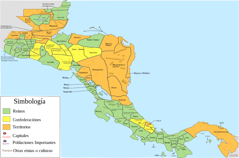
Español: Mapa de las diferentes entidades territoriales que existían en Centroamérica en el siglo XVI antes de la llegada de los españoles. En lo referente a la simbología, se tomaron en cuenta las siguientes consideraciones: Reinos, todas aquellas entidades territoriales (llamadas comúnmente señoríos o cacicazgos) que contaban con una capital y un señor principal; confederación, todas aquellas entidades conformadas por señoríos o poblaciones que aunque eran independientes tenían algún tipo de integración o alianza; territorio, todas aquellas regiones conformadas por varios señoríos o poblaciones (ya sean sedentarias, nómadas o seminómadas) que no contaban con algún tipo de integración o alianza, y de las que hay nula o escasa información de como estaban constituidos o de como se encontraban delimitados los territorios de todos o algunas entidades que se encontraban en esa región; como poblaciones importantes se toman en cuenta aquellas poblaciones que eran parte de la organización administrativa de alguna entidad, aquellas poblaciones que tuvieron un papel destacado en la conquista española de alguna entidad (como aquellas en las que se libraron batallas importantes), y las poblaciones donde se hablaban o donde aún se hablan algunas lenguas o dialectos; por último, es de mencionar que las otras etnias o culturas mostradas podrían haber estado sometidas a la entidad donde se mencionan o podrían ser independientes de dicha entidad
English: Map of the different territorial entities that existed in Central America in the XVI century before the arrive of the spanish people. With regard to symbology, the following considerations were taken: "reino" (Kingdoms), all those territorial entities (commonly called "señoríos" (lordships) or "cacicazgos") that had a capital and a principal lord; "confederación" (confederation), all those entities conformed by "señoríos" or towns that although they were independent had some type of integration or alliance; "territorio" (territory), all those regions conformed by several "señoríos" or towns (whether sedentary, nomadic or semi-nomadic) that did not count on some type of integration or alliance, and of which there is null or little information of how they were constituted or as were delimited the territories of all or someone entities that were in that region; on the other hand, as important towns are mentioned those towns that were part of the administrative organization of some entity, those towns that had a prominent role in the Spanish conquest of some entity (such as those in which important battles were fought), and the localities where some languages or dialects were spoken, or where they are still spoken today; Finally, it is worth mentioning that the other ethnic groups or cultures shown could have been submitted to the entity where they are mentioned or could be independent of said entity. |
| 日付 | |
| 原典 |
投稿者自身による著作物, for the elaboration of this picture were used the next resources: This file of wikimedia commons was used for great part of Costa Rica:  And, pictures or information of the nexts documents, publications or books:
|
| 作者 | Juan Miguel |
ライセンス
この作品の著作権者である私は、この作品を以下のライセンスで提供します。
このファイルはクリエイティブ・コモンズ 表示-継承 3.0 非移植ライセンスのもとに利用を許諾されています。
- あなたは以下の条件に従う場合に限り、自由に
- 共有 – 本作品を複製、頒布、展示、実演できます。
- 再構成 – 二次的著作物を作成できます。
- あなたの従うべき条件は以下の通りです。
- 表示 – あなたは適切なクレジットを表示し、ライセンスへのリンクを提供し、変更があったらその旨を示さなければなりません。これらは合理的であればどのような方法で行っても構いませんが、許諾者があなたやあなたの利用行為を支持していると示唆するような方法は除きます。
- 継承 – もしあなたがこの作品をリミックスしたり、改変したり、加工した場合には、あなたはあなたの貢献部分を元の作品とこれと同一または互換性があるライセンスの下に頒布しなければなりません。
ファイルの履歴
過去の版のファイルを表示するには、その版の日時をクリックしてください。
| 日付と時刻 | サムネイル | 寸法 | 利用者 | コメント | |
|---|---|---|---|---|---|
| 現在の版 | 2022年12月5日 (月) 06:23 | | 250,980 × 165,770 (499キロバイト) | Juan Miguel | Arreglando algunos detalles |
| 2019年5月5日 (日) 08:34 |  | 250,976 × 165,771 (664キロバイト) | Juan Miguel | Arreglando tamaño de fuente de algunos textos | |
| 2019年5月5日 (日) 08:30 |  | 250,976 × 165,771 (663キロバイト) | Juan Miguel | Arreglando tamaño de fuente de algunos textos | |
| 2019年5月5日 (日) 08:25 |  | 250,976 × 165,771 (663キロバイト) | Juan Miguel | Arreglando algunos textos | |
| 2019年5月5日 (日) 06:18 |  | 250,976 × 165,771 (661キロバイト) | Juan Miguel | Agregó capitales y otras poblaciones importantes, con lo cuál también se mejora los límites entre varias entidades. Además se añaden otras etnias y culturas que pueden formar parte de dicha entidad o ser independientes, y finalmente se amplía la imagen para que los diversos elementos se han más visibles | |
| 2018年12月18日 (火) 05:16 |  | 15,744 × 11,093 (276キロバイト) | Juan Miguel | Correcciones menores | |
| 2018年12月17日 (月) 10:52 |  | 15,744 × 11,093 (277キロバイト) | Juan Miguel | Pequeñas correciones | |
| 2018年10月22日 (月) 03:02 |  | 15,744 × 11,093 (278キロバイト) | Juan Miguel | Arreglo menor en el cuadro de simbología | |
| 2018年10月22日 (月) 02:44 |  | 15,744 × 11,093 (278キロバイト) | Juan Miguel | Arreglo algunas fronteras, pongo colores claros, reduzco la cantidad de colores y año el cuadro de simbología. | |
| 2017年7月16日 (日) 10:13 |  | 15,744 × 11,093 (274キロバイト) | Juan Miguel | Arreglo algunas fronteras y agrego el nombre de los lagos y el color a los océanos. |
ファイルの使用状況
以下のページがこのファイルを使用しています:
グローバルなファイル使用状況
以下に挙げる他のウィキがこの画像を使っています:
- ar.wikipedia.org での使用状況
- ast.wikipedia.org での使用状況
- bn.wikipedia.org での使用状況
- ca.wikipedia.org での使用状況
- en.wikipedia.org での使用状況
- es.wikipedia.org での使用状況
- Historia de Panamá
- Historia de Honduras
- Historia de El Salvador
- Pipil
- Historia de Guatemala
- Historia de Nicaragua
- Historia de América Central
- Historia de Belice
- Señorío de Cuzcatlán
- Idioma náhuat
- Reino quiché de Q'umarkaj
- Usuario discusión:Montgomery/Archivo 15
- Chajoma
- Honduras prehispánica
- Historia precolombina de Honduras
- Historia territorial de Panamá
- Uluas
- Gran Darién
- eu.wikipedia.org での使用状況
- fr.wikipedia.org での使用状況
- gl.wikipedia.org での使用状況
- io.wikipedia.org での使用状況
- simple.wikipedia.org での使用状況
- zh.wikipedia.org での使用状況