
ファイル:Brooklyn Bridge and World Trade Center, HAER NY-18-77.jpg

元のファイル (388 × 741 ピクセル、ファイルサイズ: 75キロバイト、MIME タイプ: image/jpeg)
ウィキメディア・コモンズのファイルページにある説明を、以下に表示します。
|
| 解説 |
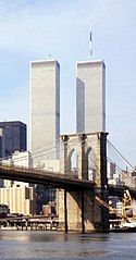
Brooklyn Bridge, Spanning East River between Brooklyn & Manhattan, New York City, New York County, NY Library of Congress information: TITLE: Brooklyn Bridge, Spanning East River between Brooklyn & Manhattan, New York City, New York County, NY CALL NUMBER: HAER, NY,31-NEYO,90-77 DATE: Documentation compiled after 1968. NOTE: Survey number HAER NY-18 Building/structure dates: 1869 SUBJECTS: NEW YORK--New York County--New York City suspension bridges COLLECTION: Historic American Engineering Record (Library of Congress) REPOSITORY: Library of Congress, Prints and Photograph Division, Washington, D.C. 20540 USA CARD #: NY1234 |
||||
| 日付 | |||||
| 原典 |
|
||||
| 作者 | |||||
| 許可 (ファイルの再利用) |
|
||||
| その他のバージョン |

.jpg)

ファイルの履歴
過去の版のファイルを表示するには、その版の日時をクリックしてください。
| 日付と時刻 | サムネイル | 寸法 | 利用者 | コメント | |
|---|---|---|---|---|---|
| 現在の版 | 2006年6月18日 (日) 01:06 | | 388 × 741 (75キロバイト) | Quasipalm | Brooklyn Bridge, Spanning East River between Brooklyn & Manhattan, New York City, New York County, NY Library of Congress information: TITLE: Brooklyn Bridge, Spanning East River between Brooklyn & Manhattan, New York City, New York County, NY CALL NUMB |
ファイルの使用状況
以下の 2 ページがこのファイルを使用しています:
グローバルなファイル使用状況
以下に挙げる他のウィキがこの画像を使っています:
- en.wikipedia.org での使用状況
- fi.wikipedia.org での使用状況
- nl.wikipedia.org での使用状況