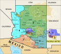
ファイル:Arizona Congressional Districts, 118th Congress.svg

ページのコンテンツが他言語でサポートされていません。

元のファイル(SVG ファイル、1,794 × 1,562 ピクセル、ファイルサイズ: 6.06メガバイト)

概要

解説
English: Map of the congressional districts of Arizona, finalised on January 19, 2022, complemented with neighbouring states, counties, major populated places, and Native American reservations and off-reservation trust lands.These conggresional districts will be put into effect from 2023 to 2033, following the 2022 US House elections. Adapted from https://web.archive.org/web/20140209101107/http://nationalatlas.gov/printable/images/pdf/congdist/pagecgd113_az.pdf (the National Atlas). Among the many shapefiles used, https://irc-az.maps.arcgis.com/home/item.html?id=b4200a4950544135b32ed3930229238a (congressional districts), https://www.arcgis.com/home/item.html?id=a53a0e7c76354c5dbb5de56a37e19154 (US counties), https://www.arcgis.com/home/item.html?id=e26f2752e86d4a8dad52ea75501480f0 (US states), https://www.arcgis.com/home/item.html?id=5508e773a06e4e959c83164c1cd198a5 (Mexican states), https://www2.census.gov/geo/tiger/TIGER2020/AIANNH/ (reservations), https://www.arcgis.com/home/item.html?id=d5e53a1068b049f69f4fb81e018d52b2 (US-Mexico international border). Data from (but not limited to), the Arizona Independent Redistricting Commission, Esri, and the US Census Bureau. Made with ArcGIS, mapshaper.org, and Inkscape. There may be some inaccuracies in the map due to human errors or incosistencies between the shapefiles used.
日付
原典 投稿者自身による著作物
作者 Twotwofourtysix

ライセンス

この作品の著作権者である私は、この作品を以下のライセンスで提供します。
Creative Commons CC-Zero このファイルはクリエイティブ・コモンズ CC0 1.0 全世界 パブリック・ドメイン提供のもとで利用可能にされています。
ある作品に本コモンズ証を関連づけた者は、その作品について世界全地域において著作権法上認められる、その者が持つすべての権利(その作品に関する権利や隣接する権利を含む。)を、法令上認められる最大限の範囲で放棄して、パブリック・ドメインに提供しています。

この作品は、たとえ営利目的であっても、許可を得ずに複製、改変・翻案、配布、上演・演奏することが出来ます。

キャプション

このファイルの内容を1行で記述してください

このファイルに描写されている項目

題材

1 1 2022

ffc09fc6772f6c83457cb4c34c4e4fabb9f1ba6d

6,355,768 バイト

1,562 ピクセル

1,794 ピクセル

ファイルの履歴

過去の版のファイルを表示するには、その版の日時をクリックしてください。

日付と時刻サムネイル寸法利用者コメント
現在の版2022年1月21日 (金) 00:502022年1月21日 (金) 00:50時点における版のサムネイル1,794 × 1,562 (6.06メガバイト)TwotwofourtysixEdits stroke
2022年1月21日 (金) 00:312022年1月21日 (金) 00:31時点における版のサムネイル1,794 × 1,562 (6.06メガバイト)TwotwofourtysixUpdates with final map, see https://www.azmirror.com/2022/01/18/redistricting-commissioners-exchange-accusations-final-map-certification-delayed/
2022年1月1日 (土) 12:152022年1月1日 (土) 12:15時点における版のサムネイル1,794 × 1,562 (5.16メガバイト)TwotwofourtysixHopefully for the last time, converts text to path, edits stroke
2022年1月1日 (土) 12:032022年1月1日 (土) 12:03時点における版のサムネイル1,794 × 1,562 (5.13メガバイト)TwotwofourtysixAdds Safford and Clifton
2022年1月1日 (土) 10:562022年1月1日 (土) 10:56時点における版のサムネイル1,794 × 1,562 (5.12メガバイト)TwotwofourtysixAdds Tucson
2022年1月1日 (土) 10:482022年1月1日 (土) 10:48時点における版のサムネイル1,794 × 1,562 (5.12メガバイト)TwotwofourtysixUploaded own work with UploadWizard

以下の​ 2 ページがこのファイルを使用しています:

グローバルなファイル使用状況

メタデータ