
ファイル:Abbasid Caliphate most extant.png
高解像度版はありません。
Abbasid_Caliphate_most_extant.png (800 × 487 ピクセル、ファイルサイズ: 85キロバイト、MIME タイプ: image/png)
ウィキメディア・コモンズのファイルページにある説明を、以下に表示します。
|
| 解説 |
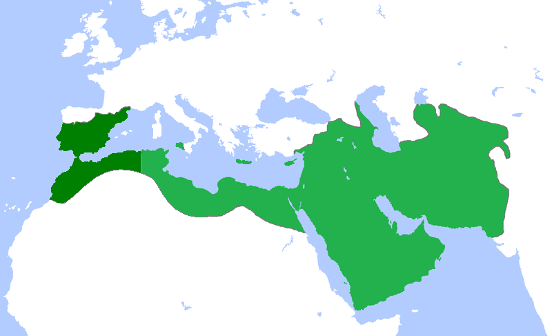
English: Locator map for the Abbasid Caliphate at its greatest extent, before the independence of al-Maghrib (Morocco and parts of Algeria) in 744 as well as al-Andalus (Spain and Portugal) in 756 |
| 日付 | (UTC) |
| 原典 | |
| 作者 |
|
この画像には画像編集が施されています。原本に対して次のデジタル的な変更が行われました。
|
この作品の著作権者である私は、この作品を以下のライセンスで提供します。
このファイルはクリエイティブ・コモンズ 表示 3.0 非移植ライセンスのもとに利用を許諾されています。
- あなたは以下の条件に従う場合に限り、自由に
- 共有 – 本作品を複製、頒布、展示、実演できます。
- 再構成 – 二次的著作物を作成できます。
- あなたの従うべき条件は以下の通りです。
- 表示 – あなたは適切なクレジットを表示し、ライセンスへのリンクを提供し、変更があったらその旨を示さなければなりません。これらは合理的であればどのような方法で行っても構いませんが、許諾者があなたやあなたの利用行為を支持していると示唆するような方法は除きます。
元のアップロードログ
This image is a derivative work of the following images:
- File:Umayyad750ADloc.png licensed with Cc-by-3.0
- 2009-04-22T16:17:51Z Gabagool 1481x902 (51495 Bytes) some corrections..
- 2009-04-20T16:10:54Z Gabagool 1481x902 (51573 Bytes) {{Information |Description={{en|1=Locator map for the Umayyad Caliphate at its greatest extent, c. AD 750. (Partially based on ''Atlas of World History'' (2007) - World 500-750, map.)}} |Source=Own work by uploader |Author=[
Uploaded with derivativeFX
ファイルの履歴
過去の版のファイルを表示するには、その版の日時をクリックしてください。
| 日付と時刻 | サムネイル | 寸法 | 利用者 | コメント | |
|---|---|---|---|---|---|
| 現在の版 | 2013年4月13日 (土) 18:50 | | 800 × 487 (85キロバイト) | Fry1989 | vandalism |
| 2013年4月13日 (土) 16:01 |  | 800 × 487 (87キロバイト) | Mouh2jijel | Reverted to version as of 08:30, 13 April 2013 | |
| 2013年4月13日 (土) 14:32 |  | 800 × 487 (85キロバイト) | Omar-toons | Reverted to version as of 23:40, 15 November 2012 rv unjustified revert | |
| 2013年4月13日 (土) 08:30 |  | 800 × 487 (87キロバイト) | Mouh2jijel | Reverted to version as of 18:50, 8 April 2013 | |
| 2013年4月13日 (土) 06:18 |  | 800 × 487 (85キロバイト) | Omar-toons | Reverted to version as of 23:40, 15 November 2012 unjustified revert | |
| 2013年4月8日 (月) 18:50 |  | 800 × 487 (87キロバイト) | Mouh2jijel | Reverted to version as of 17:29, 24 April 2012 | |
| 2012年11月15日 (木) 23:40 |  | 800 × 487 (85キロバイト) | Omar-toons | moving southern Ifriqiyan limits a little bit to the north | |
| 2012年4月24日 (火) 17:29 |  | 800 × 487 (87キロバイト) | Cplakidas | corrections: Sardinia and Corsica were never taken, and Sicily was not completely conquered until the 870s | |
| 2011年4月25日 (月) 19:11 |  | 800 × 487 (87キロバイト) | باسم | added a few Mediterranean islands | |
| 2011年4月25日 (月) 18:12 |  | 800 × 487 (87キロバイト) | باسم | {{Information |Description={{en|1=Locator map for the Abbasid Caliphate at its greatest extent, before the independence of al maghrib (morocco and parts of algeria) as well as al andalus (Spain and Portugal)}} |Source=*File:Umayyad750ADloc.png |Date |
ファイルの使用状況
以下のページがこのファイルを使用しています:
グローバルなファイル使用状況
以下に挙げる他のウィキがこの画像を使っています:
- ar.wikipedia.org での使用状況
- العراق
- بغداد
- تاريخ العراق
- البصرة
- تاريخ إسلامي
- خلافة إسلامية
- الدولة العباسية
- غامد
- برامكة
- قائمة الخلفاء
- بوابة:الإسلام/مقالة مختارة
- تاريخ اليمن الإسلامي
- بوابة:الإمبراطورية الروسية
- بوابة:الإمبراطورية الروسية/بوابات شقيقة
- ويكيبيديا:مقالة الصفحة الرئيسية المختارة/152
- خالد بن برمك
- الممالك في إفريقيا قبل الاستعمار
- يحيى البرمكي
- بوابة:مكة/مقالة مختارة/أرشيف
- بوابة:مكة/مقالة مختارة/10
- بوابة:الأديان/تاريخ ديني
- بوابة:الإسلام/دولة مختارة
- بوابة:الإسلام/دولة مختارة/3
- بوابة:العراق/مقالة مختارة/أرشيف
- بوابة:العراق/مقالة مختارة/2
- بوابة:التاريخ الإسلامي/مقالة مختارة/أرشيف
- مستخدم:باحث
- بوابة:التاريخ/فقرات منوعة/3
- بوابة:التاريخ/فقرات منوعة/أرشيف
- بوابة:التاريخ الإسلامي/دولة مختارة/أرشيف
- بوابة:الإمبراطورية الألمانية
- بوابة:الإمبراطورية الألمانية/بوابات شقيقة
- بوابة:إمبراطورية اليابان
- بوابة:إمبراطورية اليابان/بوابات شقيقة
- بوابة:الخلافة الراشدة
- بوابة:الدولة الأموية
- ويكيبيديا:قائمة اليوم المختارة/يوليو 2015
- بوابة:التاريخ الإسلامي/دولة مختارة/4
- قالب:قائمة اليوم المختارة/2015-07-04
- بوابة:الإمبراطورية الفرنسية الأولى/بوابات شقيقة
- بوابة:الإمبراطورية الفرنسية الأولى
- بوابة:الإمبراطورية النمساوية/بوابات شقيقة
- بوابة:الإمبراطورية النمساوية
- بوابة:العالم الإسلامي
- قالب:مواضيع متعلقة 3
- قالب:مواضيع متعلقة 3/شرح
- بوابة:العالم الإسلامي/تاريخ
- بوابة:العالم الإسلامي/مواضيع متعلقة
- بوابة:الدولة العباسية/واجهة
- بوابة:الدولة العباسية
このファイルのグローバル使用状況を表示する。