
ファイル:AWASE AIRFIELD in 1949.jpg

元のファイル (5,068 × 6,287 ピクセル、ファイルサイズ: 3.67メガバイト、MIME タイプ: image/jpeg)
ウィキメディア・コモンズのファイルページにある説明を、以下に表示します。
|
概要
| 解説 |
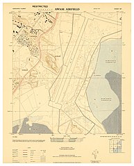
English: "......The AWASE area was captured during the first week of the Battle of Okinawa. The area was then surveyed for possible airbase construction in late April 1945 and the 36th Naval Construction Battalion commenced construction of a 5000 ft fighter airstrip there on 23 April.
Construction of the airfield was delayed by torrential rain in late May and early June and the diversion of the heavy earth-moving equipment to the maintenance of supply roads. On 30 June 1945 the base was declared operational and the first aircraft from Marine Air Group 33 (MAG-33) landed at the airfield. By March 1977 --- five years after Okinawa's reversion to Japan --- all of the airfield area had been returned to Japanese control. All that remains of the original Navy / Marine complex today is the U.S. Navy's Awase Communication Station at the tip of the Awase peninsula, right next to the present day SAM'S BY THE SEA restaurant......" --- en.wikipedia.org/wiki/Awase_Airfield Largely forgotten, and completely unknown by the generations of Okinawans born and living on the spot today, the AWASE AIRFIELD still lingers in the memories of many old-timers on Okinawa. The Airfield also figures in some older books about Okinawa, including references made to it in THE TEAHOUSE OF THE AUGUST MOON, the popular 1951 novel by Vern Sneider. The Airfield is also referenced a few times in the prize-winning, 1971 Novella by Higashi Mineo OKINAWA NO SHOUNEN. [Later translated into English by Steve Rabson, and published in 1989 as CHILD OF OKINAWA ]. The old Airfield and all the open parking bays associated with it are now long gone, but the broad landing strip affected the way that later roads and infrastructure were designed and laid down. Interestingly, a huge chunk of the runway area is visible on the January 4th, 2015 GOOGLE EARTH image seen HERE : ♥ 26°18'58.37"N 127°49'29.14"E This naked [in 2015], north-central spot along the old Airstrip hosted the AWASE HYPER-MART and TOYS "Я" US, until the complex went out of business a few years ago, and was razed. The North end of the runway is buried under a spot just south-east of a couple of school-yards HERE : ♥ 26°19'15.06"N 127°49'36.40"E The South end of the runway sat in what is now the middle of the Sports Stadium HERE : ♥ 26°18'30.77"N 127°49'16.16"E For those who love these old maps, and want to use the above post to superimpose over modern maps or aerial photographs of Okinawa, please use the above three coordinates to get started. If you are a true map maniac, note that this is a wartime GPO printed document in the PUBIC DOMAIN. Feel free to download my largest sizes for your own use, personal study, and safe-keeping on your own hard drive : LARGE SIZES : www.flickr.com/photos/okinawa-soba/23990406574/sizes/l BOOK NOTE : The Steve Rabson-translated Novella, CHILD OF OKINAWA, is pictured on this site : ♥ ieas.berkeley.edu/publications/jrm10.html Professor Rabson was stationed at CAMP HENOKO back in the 1960s, and was already an "old hand" concerning Okinawa many years before I showed up in 1973. Cheers ! |
| 日付 | |
| 原典 | https://www.flickr.com/photos/okinawa-soba/23990406574/ |
| 作者 | Okinawa Soba (Rob) |
ライセンス
| この画像は当初、Okinawa Soba (Rob) によって Flickr の https://flickr.com/photos/24443965@N08/23990406574 に投稿されたものです。2024-04-20、FlickreviewR 2 ボットによってレビューされ、Public Domain Mark のライセンスで提供されていることが確認されました。 |
この著作物は、著作者が Flickr 上で「パブリックドメインの著作物」と宣言し、クリエイティブ・コモンズ パブリック・ドメイン・マーク 1.0 タグを付けてパブリックドメインの状態で公表したものです。 |
||
パブリック・ドメイン・マークは、著作権の許諾ではなく、著作物がパブリックドメインの状態にあることを示すために使用するシンボルです。著作者又は著作権者によってマークが付けられている場合は、コミュニティの合意により、アメリカ合衆国及びパブリックドメインの状態での公表が法的に可能な国において、そのような著作物はパブリックドメインの状態にあると見做されます。これが不可能な国においては、著作物の著作権状態は未確定です。 | ||
著作権者以外がパブリック・ドメイン・マークのタグを付けた場合は、こちらにあるようなより具体的な著作権タグを適用しなければなりません。これが自身の著作物である場合は、代わりに {{Cc-zero}} を使用して下さい。
|
ファイルの履歴
過去の版のファイルを表示するには、その版の日時をクリックしてください。
| 日付と時刻 | サムネイル | 寸法 | 利用者 | コメント | |
|---|---|---|---|---|---|
| 現在の版 | 2022年2月26日 (土) 05:31 | | 5,068 × 6,287 (3.67メガバイト) | Alain Parks | Uploaded a work by Okinawa Soba (Rob) from https://www.flickr.com/photos/okinawa-soba/23990406574/ with UploadWizard |
ファイルの使用状況
以下のページがこのファイルを使用しています: